Ofbyld:Western Cape 2011 population density map.svg

Size of this PNG preview of this SVG file: 760 × 599 piksels. Oare resolúsjes: 304 × 240 piksels | 609 × 480 piksels | 974 × 768 piksels | 1.280 × 1.009 piksels | 2.560 × 2.019 piksels | 1.126 × 888 piksels.
Oarspronklik bestân (SVG-bestân, nominaal 1.126 × 888 pixels, bestânsgrutte: 741 KB)
Gearfetting
| Beskriuwing |
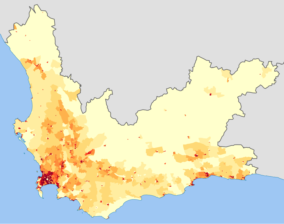
English: Population density map of the Western Cape province of South Africa, from the 2011 Census, at the "Small Area" level.
<1 inhabitant/km²
1–3 inhabitants/km²
3–10 inhabitants/km²
10–30 inhabitants/km²
30–100 inhabitants/km²
100–300 inhabitants/km²
300–1000 inhabitants/km²
1000–3000 inhabitants/km²
>3000 inhabitants/km²
Projection is Albers Equal-Area Conic, with standard parallels at 25.5° S and 31.5° S, and origin at 28.5° S 25.5° E. |
| Datum | |
| Boarne | Statistics South Africa's Census 2011 is the source of the basic population data. The map results from my own processing of the data. |
| Auteur | Htonl |
| Tastimming (Reusing this file) |
http://beta2.statssa.gov.za/?page_id=425 |
Lisinsje
The following license applies to the population data on which the map is based:

|
The copyright holder of this file, Statistics South Africa (States SA), allows anyone to use it for any purpose, provided that the copyright holder is properly attributed. Redistribution, derivative work, commercial use, and all other use is permitted. |
Nammefermelding:
Statistics South Africa (States SA)
|
The following tag applies to the map itself:
| I, the copyright holder of this work, release this work into the public domain. This applies worldwide. In some countries this may not be legally possible; if so: I grant anyone the right to use this work for any purpose, without any conditions, unless such conditions are required by law. |
Triemskiednis
Klik op in datum/tiid om it bestân te besjen sa't it op dat stuit wie.
| Datum/Tiid | Miniatuer | ôfmjittings | Meidogger | Opmerking | |
|---|---|---|---|---|---|
| lêste | 22 okt 2013, 20.35 | | 1.126 × 888 (741 KB) | Htonl | == {{int:filedesc}} == {{Information |Description={{en|1=Population density map of the Western Cape province of South Africa, from the 2011 Census, at the "Small Area" level. {{legend|#ffffcc|<1 inhabitant/km²}} {{legend|#ffeda0|1–3 inhabitants/k... |
Bestânsgebrûk
De neikommende side brûkt dit bestân:
Globaal bestânsgebrûk
De neikommende oare wiki's brûke dit bestân:
- Gebrûk op be.wikipedia.org
- Gebrûk op de.wikipedia.org
- Gebrûk op en.wikipedia.org
- Gebrûk op he.wikipedia.org
- Gebrûk op hu.wikipedia.org
- Gebrûk op hy.wikipedia.org
- Gebrûk op ka.wikipedia.org
- Gebrûk op ru.wikipedia.org