Ofbyld:White Sea Canal map.png

Grutte fan dit proefbyld: 699 × 600 piksels. Oare resolúsjes: 280 × 240 piksels | 560 × 480 piksels | 1.000 × 858 piksels.
Oarspronklik bestân (1.000 × 858 pixels, bestânsgrutte: 351 KB, MIME-type: image/png)

|
This locator map image could be re-created using vector graphics as an SVG file. This has several advantages; see Commons:Media for cleanup for more information. If an SVG form of this image is available, please upload it and afterwards replace this template with
{{vector version available|new image name}}.
It is recommended to name the SVG file “White Sea Canal map.svg”—then the template Vector version available (or Vva) does not need the new image name parameter. |
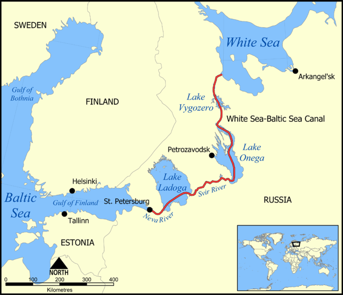
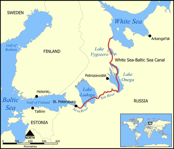
This map shows the route of the White Sea-Baltic Sea Canal ("Belomorkanal") between the White Sea and Baltic Sea. It shows the lakes Vygozero, Onega, and Ladoga, and the Svir' and Neva rivers too.
Created by NormanEinstein, December 6, 2005.
I, the copyright holder of this work, hereby publish it under the following license:

|
Der wurdt tastimming jûn ta kopiearjen, fersprieden en/of wizigjen fan dit dokumint ûnder de betinksten fan de GNU-lisinsje foar iepen dokumintaasje, ferzje 1.2, as eltse lettere ferzje útjûn troch de Free Software Foundation; sûnder Ynfariante Seksjes, sûnder Omkaftteksten foar de Foarkante en sûnder Omkaftteksten foar de Efterkante. In kopy fan de lisinsje is opnaam yn de seksje "Text of the GNU Free Documentation License". |
| This file is licensed under the Creative Commons Attribution-Share Alike 3.0 Unported license. | ||
| ||
| This licensing tag was added to this file as part of the GFDL licensing update. |
Derivative works
[]
-
 Deutsch
 -
 English
 -
 français
 -
 hrvatski
 -
 עברית
עברית


Triemskiednis
Klik op in datum/tiid om it bestân te besjen sa't it op dat stuit wie.
| Datum/Tiid | Miniatuer | ôfmjittings | Meidogger | Opmerking | |
|---|---|---|---|---|---|
| lêste | 6 des 2005, 19.59 | | 1.000 × 858 (351 KB) | NormanEinstein | This map shows the route of the White Sea-Baltic Sea Canal between the White Sea and Baltic Sea. (Heh heh.) It shows the lakes Vygozero, Onega, and Ladoga, and the Sivr and Neva rivers too. Created by NormanEinstein, December 6, 2005. {{GFDL-self}} [[C |
Bestânsgebrûk
De neikommende 3 siden brûke dit bestân:
Globaal bestânsgebrûk
De neikommende oare wiki's brûke dit bestân:
- Gebrûk op af.wikipedia.org
- Gebrûk op ar.wikipedia.org
- Gebrûk op arz.wikipedia.org
- Gebrûk op ast.wikipedia.org
- Gebrûk op bg.wikipedia.org
- Gebrûk op ca.wikipedia.org
- Gebrûk op cs.wikipedia.org
- Gebrûk op da.wikipedia.org
- Gebrûk op en.wikipedia.org
- Gebrûk op es.wikipedia.org
- Gebrûk op fa.wikipedia.org
- Gebrûk op fr.wikipedia.org
- Gebrûk op hi.wikipedia.org
- Gebrûk op id.wikipedia.org
- Gebrûk op incubator.wikimedia.org
- Gebrûk op is.wikipedia.org
- Gebrûk op it.wikipedia.org
- Gebrûk op ja.wikipedia.org
- Gebrûk op ko.wikipedia.org
- Gebrûk op lt.wikipedia.org
- Gebrûk op lv.wikipedia.org
- Gebrûk op mk.wikipedia.org
- Gebrûk op nl.wikipedia.org
- Gebrûk op no.wikipedia.org
- Gebrûk op pl.wikipedia.org
- Gebrûk op pt.wikipedia.org
- Gebrûk op qu.wikipedia.org
- Gebrûk op ro.wikipedia.org
- Gebrûk op ru.wikipedia.org
- Gebrûk op simple.wikipedia.org
- Gebrûk op sl.wikipedia.org
- Gebrûk op sq.wikipedia.org
- Gebrûk op sv.wikipedia.org
Mear globaal gebrûk fan dit bestân besjen.