Ofbyld:Ws-map.png
Gjin hegere resolúsje beskikber.
Ws-map.png (629 × 317 pixels, bestânsgrutte: 8 KB, MIME-type: image/png)
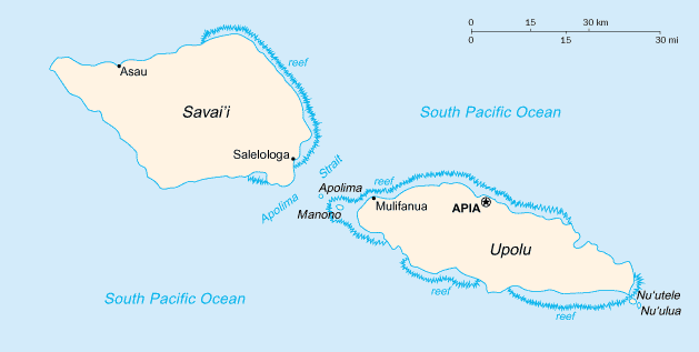
Italiano: Mappa delle Samoa

|
This map has been uploaded by Electionworld from en.wikipedia.org to enable the |
CIA map
This image is in the public domain because it contains materials that originally came from the United States Central Intelligence Agency's World Factbook.
|
 |
Triemskiednis
Klik op in datum/tiid om it bestân te besjen sa't it op dat stuit wie.
| Datum/Tiid | Miniatuer | ôfmjittings | Meidogger | Opmerking | |
|---|---|---|---|---|---|
| lêste | 13 feb 2022, 07.18 | | 629 × 317 (8 KB) | Lojwe | Cropped 1 % horizontally, 1 % vertically using CropTool with precise mode. |
| 29 nov 2006, 01.20 |  | 633 × 321 (9 KB) | Electionworld | {{ew|en|Cantus}} CIA map {{PD-USGov-CIA-WF}} Category:Maps of Samoa |
Bestânsgebrûk
De neikommende side brûkt dit bestân:
Globaal bestânsgebrûk
De neikommende oare wiki's brûke dit bestân:
- Gebrûk op ast.wikipedia.org
- Gebrûk op es.wikipedia.org
- Gebrûk op it.wikipedia.org
- Gebrûk op mt.wikipedia.org
- Gebrûk op nl.wikipedia.org
- Gebrûk op ru.wikipedia.org
- Gebrûk op scn.wikipedia.org
- Gebrûk op ti.wikipedia.org
- Gebrûk op to.wikipedia.org