Ofbyld:Adelaide (short route).svg

Size of this PNG preview of this SVG file: 800 × 452 piksels. Oare resolúsjes: 320 × 181 piksels | 640 × 362 piksels | 1.024 × 579 piksels | 1.280 × 723 piksels | 2.560 × 1.446 piksels | 1.740 × 983 piksels.
Oarspronklik bestân (SVG-bestân, nominaal 1.740 × 983 pixels, bestânsgrutte: 85 KB)
Gearfetting
| Beskriuwing |
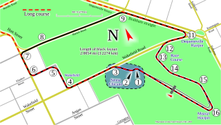
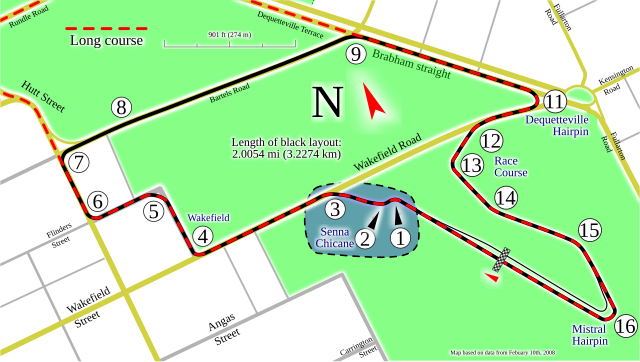
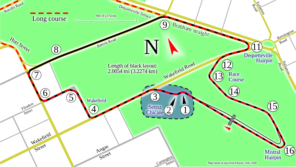
English: Track map of the short circuit for Adelaide Street Circuit. The dashed red line is the long route (see related image listed below). |
| Datum | |
| Boarne | Eigen wurk |
| Auteur | Will Pittenger |
| Oare ferzjes |
|
| SVG genesis |


.svg)
.svg)
| Camera location | | View this and other nearby images on: OpenStreetMap |
|---|
.svg¶ms=-34.927444_N_0138.617611_E_globe:Earth_type:camera__&language=fy)
Lisinsje
I, the copyright holder of this work, hereby publish it under the following licenses:
This file is licensed under the Creative Commons Attribution-Share Alike 3.0 Unported license.
- Fiel jo frij:
- te dielen – it wurk te kopiearjen, fersprieden en út te stjoeren
- te fermingen – it wurk oan te passen
- Under de neikommende betingsten:
- Nammefermelding – You must give appropriate credit, provide a link to the license, and indicate if changes were made. You may do so in any reasonable manner, but not in any way that suggests the licensor endorses you or your use.
- Lyk diele – If you remix, transform, or build upon the material, you must distribute your contributions under the same or compatible license as the original.

|
Der wurdt tastimming jûn ta kopiearjen, fersprieden en/of wizigjen fan dit dokumint ûnder de betinksten fan de GNU-lisinsje foar iepen dokumintaasje, ferzje 1.2, as eltse lettere ferzje útjûn troch de Free Software Foundation; sûnder Ynfariante Seksjes, sûnder Omkaftteksten foar de Foarkante en sûnder Omkaftteksten foar de Efterkante. In kopy fan de lisinsje is opnaam yn de seksje "Text of the GNU Free Documentation License". |
You may select the license of your choice.
Triemskiednis
Klik op in datum/tiid om it bestân te besjen sa't it op dat stuit wie.
| Datum/Tiid | Miniatuer | ôfmjittings | Meidogger | Opmerking | |
|---|---|---|---|---|---|
| lêste | 17 nov 2022, 03.10 | | 1.740 × 983 (85 KB) | ZandDev | fix brace not closed |
| 16 jun 2010, 09.10 |  | 1.740 × 983 (85 KB) | Will Pittenger | All new map with more info | |
| 29 jul 2008, 06.19 |  | 1.209 × 1.172 (112 KB) | Will Pittenger | {{Information |Description={{en|1=Track map of the short circuit for w:Adelaide Street Circuit. The yellow and light gray lines are local streets included for reference. The thin black line in the streets is the long layouta and is also included fo |
Bestânsgebrûk
De neikommende side brûkt dit bestân:
Globaal bestânsgebrûk
De neikommende oare wiki's brûke dit bestân:
- Gebrûk op ar.wikipedia.org
- Gebrûk op bg.wikipedia.org
- Gebrûk op ca.wikipedia.org
- Gebrûk op da.wikipedia.org
- Gebrûk op en.wikipedia.org
- Adelaide Street Circuit
- Adelaide 500
- Portal:Australia/Anniversaries/November
- Portal:Australia/Anniversaries/November/November 3
- 2006 Clipsal 500 Adelaide
- 2007 Clipsal 500
- 2008 Clipsal 500
- 1999 Sensational Adelaide 500
- 2000 Clipsal 500
- 2001 Clipsal 500
- 2002 Clipsal 500
- 2009 Clipsal 500
- 2003 Clipsal 500
- 2010 Clipsal 500
- 2011 Clipsal 500
- 2012 Clipsal 500
- 2013 Clipsal 500 Adelaide
- 2014 Clipsal 500
- 2015 Clipsal 500
- 2005 Clipsal 500
- 2016 Clipsal 500
- 2004 Clipsal 500
- 2017 Clipsal 500 Adelaide
- List of Australian Touring Car Championship circuits
- 2018 Adelaide 500
- 2019 Adelaide 500
- User:Linkyblinky/2020 Adelaide 500
- 2020 Adelaide 500
- 2022 Adelaide 500
- Gebrûk op en.wikivoyage.org
- Gebrûk op es.wikipedia.org
- Gebrûk op es.wikivoyage.org
- Gebrûk op eu.wikipedia.org
- Gebrûk op fa.wikipedia.org
- Gebrûk op fi.wikipedia.org
- Gebrûk op gl.wikipedia.org
- Gebrûk op he.wikipedia.org
- Gebrûk op he.wikivoyage.org
- Gebrûk op hu.wikipedia.org
- Gebrûk op id.wikipedia.org
- Gebrûk op ja.wikipedia.org
- Gebrûk op lt.wikipedia.org
Mear globaal gebrûk fan dit bestân besjen.
.svg)
.svg)