Ofbyld:Antarctica 1912 edit.jpg
Oarspronklik bestân (4.940 × 4.296 pixels, bestânsgrutte: 17,94 MB, MIME-type: image/jpeg)
Gearfetting
| Beskriuwing |
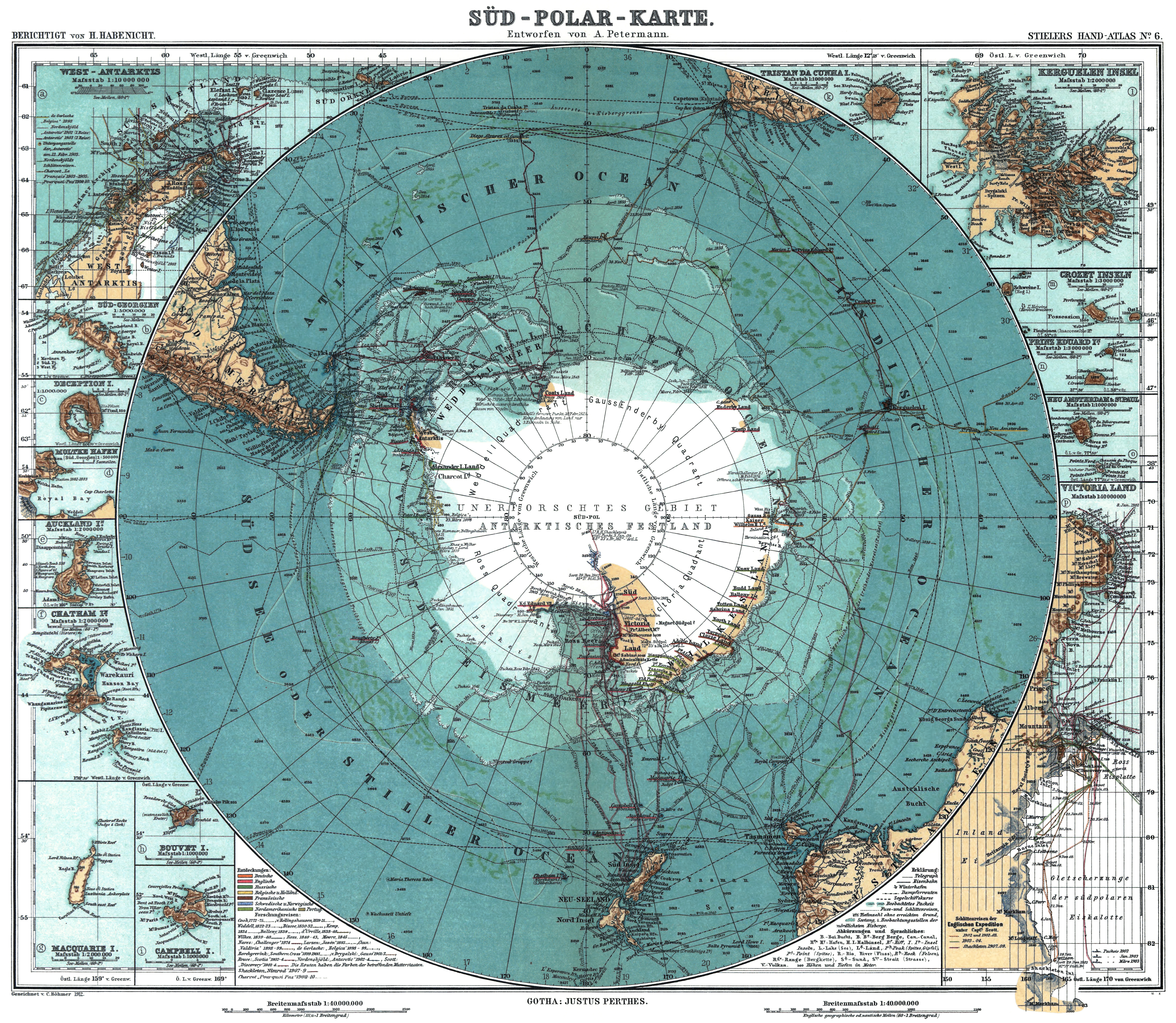
Deutsch: Karte der Antarktis. Maßstab [ca. 1:40,000,000]. farbig, 34 × 41 cm. English: Map of Antarctica. Scale [ca. 1:40,000,000]. Col., 34 × 41 cm. Français : Carte de l'Antarctique, échelle 1:40 000 000e, couleur, 34 × 41 cm. Português: Mapa da Antárctica. Escala [ca. 1:40,000,000]. Cor., 34 × 41 cm. עברית : מפת אנטרטיקה (קנה מידה 1:40,000,000). |
||||||||||||||||||||||||||||||||||||
| Datum | |||||||||||||||||||||||||||||||||||||
| Boarne |
Stieler Handatlas, 9. von Grund aus neubearb. und neugestochene Aufl. 8. berichtigter Abdruck. Verlag J. Perthes, Gotha, 1912.
|
||||||||||||||||||||||||||||||||||||
| Auteur |
Petermann, A.; Habenicht, H.; Böhmer, C.
|
||||||||||||||||||||||||||||||||||||
| Oare ferzjes |
|
||||||||||||||||||||||||||||||||||||


Lisinsje
|
This work is in the public domain in its country of origin and other countries and areas where the copyright term is the author's life plus 100 years or fewer. This work is in the public domain in the United States because it was published (or registered with the U.S. Copyright Office) before January 1, 1929. | |
| This file has been identified as being free of known restrictions under copyright law, including all related and neighboring rights. | |
Assessment
|

This image was selected as picture of the day on Wikimedia Commons for 19 November 2010. It was captioned as follows: English: Map of Antarctica. Scale [ca. 1:40,000,000]. Col., 34 × 41 cm. Other languages:
Deutsch: Karte der Antarktis – Maßstab 1:40 000 000 – Größe: 34 × 41 cm. English: Map of Antarctica. Scale [ca. 1:40,000,000]. Col., 34 × 41 cm. Español: Mapa de la Antártida. Escala ~ 1:40.000.000. Color, 34×41 cm. Français : Carte de l'Antarctique, échelle 1:40 000 000e, couleur, 34 × 41 cm. Íslenska: Kort af suðurskautslandinu. Mælikvarði kortsins er 1:40.000.000 Magyar: Antarktika színezett térképe méretarány 1:40 000 000, méret: 34 × 41 cm (Stieler Handatlas, 1912) Nederlands: Kaart van de Antarctis (Antarctica en omliggende Zuidelijke Oceaan). Schaal 1:40.000.000. Afmetingen: 34 × 41 cm. Polski: Mapa Antarktyki w skali 1:40.000.000. Português: Mapa de 1912 da Antártida (escala: 1:40.000.000). Македонски: Карта на Антарктикот. размер: 1:4.000.000. димензии: 34 × 41 cm. മലയാളം : അന്റാർട്ടിക്കയുടെ ഭൂപടം. അളവ് ഏകദേശം ~ 1:40,000,000. 한국어: 남극 지도. 축척 약 1:40,000,000. 34 × 41 cm. 日本語: 1912年出版の南極地図。原寸縮尺約40,000,000分の1、高さ34センチメートル、幅41センチメートル。 中文: 1912年版本的南极洲地图,比例尺约为1:40,000,000,尺寸34 x 41 cm. العربية : خريطة للقارة القطبية الجنوبية (أنتاركتيكا). مقياس الرسم 1 إلى 40 مليون . أبعاد الخريطة 34 × 41 سم. |
Triemskiednis
Klik op in datum/tiid om it bestân te besjen sa't it op dat stuit wie.
| Datum/Tiid | Miniatuer | ôfmjittings | Meidogger | Opmerking | |
|---|---|---|---|---|---|
| lêste | 3 okt 2019, 18.50 | | 4.940 × 4.296 (17,94 MB) | Reseletti | cropped some whitespace, without reencoding |
| 18 mrt 2010, 00.15 |  | 5.676 × 4.763 (17,84 MB) | Christoph Braun | revised to baseline "standard", progressive compression removed, used edited tif as bias (see other versions) | |
| 15 mrt 2010, 23.06 |  | 5.676 × 4.763 (16,32 MB) | Christoph Braun | reverted to 300dpi | |
| 14 mrt 2010, 19.24 |  | 5.676 × 4.763 (16,32 MB) | Christoph Braun | {{Information |Description={{en|1=Map of Antarctica. Scale [ca. 1:40,000,000]. Col., 34 x 41 cm.}} {{de|1=Karte der Antarktis. Maßstab [ca. 1:40,000,000]. farbig, 34 x 41 cm.}} |Source={{LOC-map|id=g9800.ct000774}} |Author=Petermann, A.; Habenicht, H.; B |
Bestânsgebrûk
De neikommende side brûkt dit bestân:
Globaal bestânsgebrûk
De neikommende oare wiki's brûke dit bestân:
- Gebrûk op af.wikipedia.org
- Gebrûk op ba.wikipedia.org
- Gebrûk op be-tarask.wikipedia.org
- Gebrûk op bn.wikipedia.org
- Gebrûk op ca.wikipedia.org
- Gebrûk op ce.wikipedia.org
- Gebrûk op crh.wikipedia.org
- Gebrûk op cv.wikipedia.org
- Gebrûk op da.wikipedia.org
- Gebrûk op de.wikipedia.org
- Gebrûk op en.wikipedia.org
- Gebrûk op es.wikipedia.org
- Gebrûk op fa.wikipedia.org
- Gebrûk op frp.wikipedia.org
- Gebrûk op fr.wikipedia.org
- Gebrûk op he.wikipedia.org
- Gebrûk op hu.wikipedia.org
- Gebrûk op it.wikipedia.org
- Gebrûk op ja.wikipedia.org
- Gebrûk op ko.wikipedia.org
- Gebrûk op krc.wikipedia.org
- Gebrûk op lbe.wikipedia.org
- Gebrûk op lb.wikipedia.org
- Gebrûk op mg.wikipedia.org
- Gebrûk op mk.wikipedia.org
- Gebrûk op nl.wikipedia.org
Mear globaal gebrûk fan dit bestân besjen.