Ofbyld:Atlanta Central.png

Grutte fan dit proefbyld: 514 × 600 piksels. Oare resolúsjes: 206 × 240 piksels | 589 × 687 piksels.
Oarspronklik bestân (589 × 687 pixels, bestânsgrutte: 500 KB, MIME-type: image/png)
| Beskriuwing |
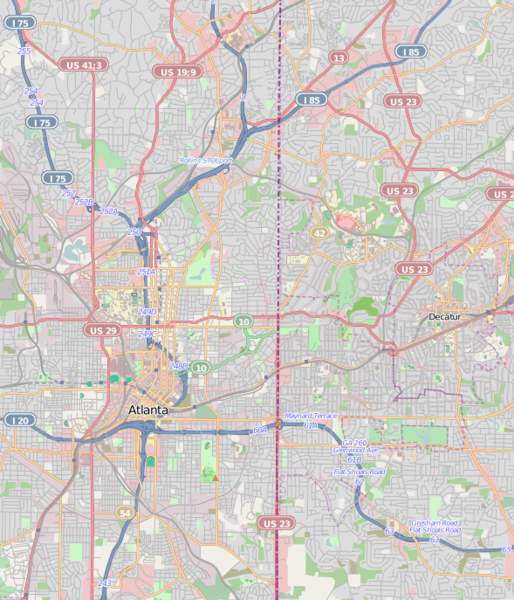
This map was created from OpenStreetMap project data, collected by the community. This map may be incomplete, and may contain errors. Don't rely solely on it for navigation.
|
||||||||||||
| Datum | (see file history) | ||||||||||||
| Boarne | openstreetmap.org | ||||||||||||
| Auteur | OpenStreetMap contributors | ||||||||||||
| Tastimming (Reusing this file) |
All OpenStreetMap data and maps are Creative Commons "CC-BY-SA 2.0" licensed This file is licensed under the Creative Commons Attribution-Share Alike 2.0 Generic license.
|
||||||||||||
Atlanta Central.png == Usage == * This template can be used without any parameter, but it also supports setting the source=, the date=, the authors=, location= and the other_versions=. If source is not used the parameter name has to be used. * The parameters top=, bottom=, left=, and right= can be used to store the border coordinates of the map. This information can be useful for various mapping templates that are used in various Wikimedia projects. Atlanta Central.pngCategory:Internationalization templates using LangSwitch
Triemskiednis
Klik op in datum/tiid om it bestân te besjen sa't it op dat stuit wie.
| Datum/Tiid | Miniatuer | ôfmjittings | Meidogger | Opmerking | |
|---|---|---|---|---|---|
| lêste | 17 mrt 2011, 00.42 | | 589 × 687 (500 KB) | Keizers | updated |
| 16 mrt 2011, 19.37 |  | 580 × 707 (671 KB) | Keizers | ({{Information |Description={{LangSwitch |de=Diese Karte {{#if: {{{location|}}}|von {{{location}}} }} entstammt dem offenen OpenStreetMap Projekt, erstellt von der Community. <small>Diese Karte kann unvollständig sein oder Fehler enthalten. Verlasse dich |
Bestânsgebrûk
De neikommende side brûkt dit bestân:
Globaal bestânsgebrûk
De neikommende oare wiki's brûke dit bestân:
- Gebrûk op ar.wikipedia.org
- Gebrûk op arz.wikipedia.org
- Gebrûk op ban.wikipedia.org
- Gebrûk op ceb.wikipedia.org
- Gebrûk op en.wikipedia.org
- Gresham Park, Georgia
- North Decatur, Georgia
- North Druid Hills, Georgia
- Promenade II
- Tower Square (Atlanta)
- State Farm Arena
- Midtown Atlanta
- Bobby Dodd Stadium
- Atlanta Cyclorama & Civil War Museum
- Georgia State Capitol
- Fernbank Science Center
- Inman Park
- Bankhead, Atlanta
- List of tallest buildings in Atlanta
- Grant Park, Atlanta
- Martin Luther King Jr. National Historical Park
- Atlanta History Center
- BeltLine
- Oakland Cemetery (Atlanta)
- Episcopal Cathedral of Saint Philip (Atlanta)
- Candler Park
- Georgia Governor's Mansion
- Sweet Auburn
- Atlanta Civic Center
- Techwood Homes
- West End, Atlanta
- Fairlie–Poplar, Atlanta
- Cabbagetown, Atlanta
- Druid Hills Historic District (Atlanta, Georgia)
- Reynoldstown, Atlanta
- 1180 Peachtree
- Atlanta City Hall
- Westside Park
- Ansley Park
- Rhodes Hall
- Castleberry Hill
- Mechanicsville, Atlanta
- Mary Mac's Tea Room
- Center for Puppetry Arts
- Brookwood Hills
- The Texas (locomotive)
- Sweet Auburn Curb Market
- Georgia Institute of Technology Historic District
- Old Scottish Rite Hospital building
- Garden Hills
- TWELVE Centennial Park
Mear globaal gebrûk fan dit bestân besjen.