Ofbyld:Beaver Creek Bridge in Wind Cave National Park.jpg

Grutte fan dit proefbyld: 759 × 599 piksels. Oare resolúsjes: 304 × 240 piksels | 608 × 480 piksels | 973 × 768 piksels | 1.280 × 1.011 piksels | 2.560 × 2.021 piksels | 4.799 × 3.789 piksels.
Oarspronklik bestân (4.799 × 3.789 pixels, bestânsgrutte: 1,61 MB, MIME-type: image/jpeg)
|
This is an image of a place or building that is listed on the National Register of Historic Places in the United States of America. Its reference number is 84003254. |
| Camera location | | View this and other nearby images on: OpenStreetMap |
|---|
| Beskriuwing |
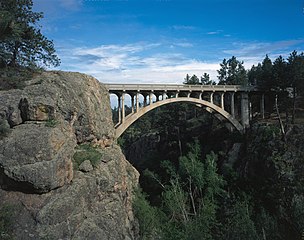
English: Eastern (downstream) side of the Beaver Creek Bridge, which carries Highway 87 over Beaver Creek near Hot Springs in Custer County, South Dakota, United States. Built in 1929 in the present boundaries of Wind Cave National Park, the bridge is listed on the National Register of Historic Places. |
||||
| Datum | Datum ûnbekend | ||||
| Boarne | Library of Congress, Prints and Photograph Division HAER: SD-53-6 | ||||
| Auteur | Ûnbekend | ||||
| Tastimming (Reusing this file) |
|

|
This image is available from the United States Library of Congress's Prints and Photographs division
under the digital ID hhh.sd0080. This tag does not indicate the copyright status of the attached work. A normal copyright tag is still required. See Commons:Licensing.
|
Triemskiednis
Klik op in datum/tiid om it bestân te besjen sa't it op dat stuit wie.
| Datum/Tiid | Miniatuer | ôfmjittings | Meidogger | Opmerking | |
|---|---|---|---|---|---|
| lêste | 30 sep 2009, 17.37 | | 4.799 × 3.789 (1,61 MB) | Cropbot | upload cropped version, operated by User:Luxo. Summary: cropped |
| 30 sep 2009, 02.12 |  | 5.176 × 4.159 (1,8 MB) | Nyttend | {{Location|43|35|4|N|103|29|19|W}} {{Information |Description={{en|Eastern (downstream) side of the {{w|Beaver Creek Bridge (Hot Springs, South Dakota|Beaver Creek Bridge}}, which carries {{w|South Dakota Highway 87|Highway 87}} over {{w|Beaver Creek (Sou |
Bestânsgebrûk
De neikommende side brûkt dit bestân:
Globaal bestânsgebrûk
De neikommende oare wiki's brûke dit bestân:
- Gebrûk op bn.wikipedia.org
- Gebrûk op de.wikipedia.org
- Gebrûk op en.wikipedia.org
- Gebrûk op es.wikipedia.org
- Gebrûk op fr.wikipedia.org
- Gebrûk op ja.wikipedia.org
- Gebrûk op ro.wikipedia.org
- Gebrûk op tr.wikipedia.org
- Gebrûk op www.wikidata.org