Ofbyld:Columbus1.PNG
Grutte fan dit proefbyld: 800 × 466 piksels. Oare resolúsjes: 320 × 187 piksels | 640 × 373 piksels | 1.024 × 597 piksels | 1.280 × 746 piksels | 1.861 × 1.085 piksels.
Oarspronklik bestân (1.861 × 1.085 pixels, bestânsgrutte: 64 KB, MIME-type: image/png)
| Beskriuwing |
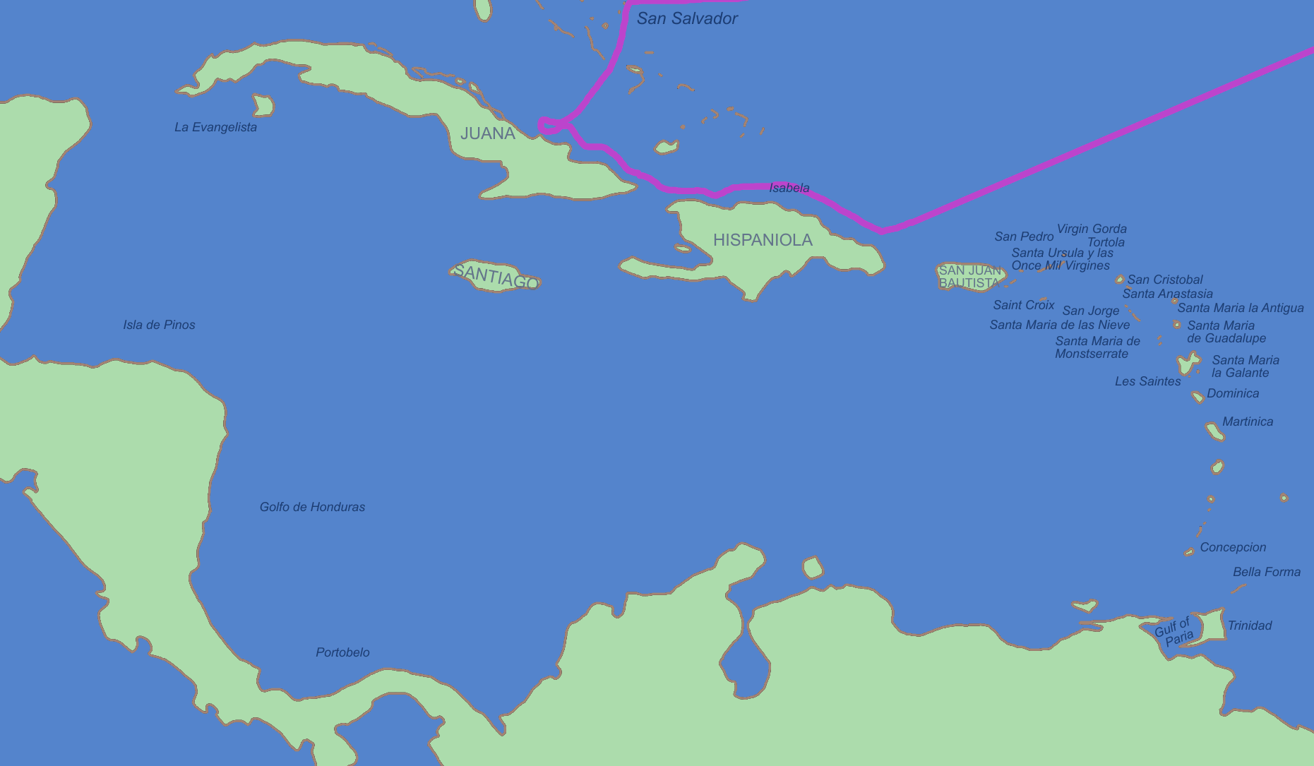
Italiano: Questo è il percorso del primo viaggio di Colombo nei Caraibi. La mappa utilizza i nomi spagnoli con cui Colombo conosceva quei luoghi.
English: This is the route of first voyage of Columbus in the Caribbean. This map shows the Spanish-given names by which Columbus would have known these places.
Čeština: Mapa první výpravy Kryštofa Kolumba. Popisky jednotlivých lokalit jsou ve španělštině, jak je znal sám Kolumbus. |
||||||||
| Boarne | |||||||||
| Auteur | |||||||||
| Tastimming (Reusing this file) |
I, the copyright holder of this work, hereby publish it under the following licenses:
You may select the license of your choice. |


|
This historical map image could be re-created using vector graphics as an SVG file. This has several advantages; see Commons:Media for cleanup for more information. If an SVG form of this image is available, please upload it and afterwards replace this template with
{{vector version available|new image name}}.
It is recommended to name the SVG file “Columbus1.svg”—then the template Vector version available (or Vva) does not need the new image name parameter. |
Triemskiednis
Klik op in datum/tiid om it bestân te besjen sa't it op dat stuit wie.
| Datum/Tiid | Miniatuer | ôfmjittings | Meidogger | Opmerking | |
|---|---|---|---|---|---|
| lêste | 13 des 2007, 19.21 | | 1.861 × 1.085 (64 KB) | Mahahahaneapneap | pngcrushed |
| 30 nov 2006, 12.51 |  | 1.861 × 1.085 (82 KB) | Roke~commonswiki | == Summary == 1st voyage of Columbus. I made the map, based on info from several maps and Wikipedia. Map uses the original Spanish names which Columbus would have known the locations as. == Licensing == {{GFDL-self}} <!--Categories--> [[Category:Maps o |
Bestânsgebrûk
Der binne gjin siden dy't dit bestân brûke.
Globaal bestânsgebrûk
De neikommende oare wiki's brûke dit bestân:
- Gebrûk op af.wikipedia.org
- Gebrûk op ba.wikipedia.org
- Gebrûk op be.wikipedia.org
- Gebrûk op bg.wikipedia.org
- Gebrûk op ca.wikipedia.org
- Gebrûk op crh.wikipedia.org
- Gebrûk op cs.wikipedia.org
- Gebrûk op de.wikipedia.org
- Gebrûk op de.wikiversity.org
- Gebrûk op en.wikipedia.org
- Gebrûk op en.wikibooks.org
- Gebrûk op eo.wikipedia.org
- Gebrûk op es.wikipedia.org
- Gebrûk op es.wikibooks.org
- Gebrûk op fi.wikipedia.org
- Gebrûk op fr.wikipedia.org
- Gebrûk op fr.wikinews.org
- Catégorie:28 octobre 2008
- Catégorie:28 octobre 2009
- Catégorie:28 octobre 2010
- Catégorie:28 octobre 2011
- Catégorie:28 octobre 2012
- Modèle:Éphéméride-28 octobre
- Évènements du 28 octobre 2012
- Catégorie:28 octobre 2013
- Évènements du 28 octobre 2013
- Catégorie:28 octobre 2014
- Évènements du 28 octobre 2014
- Catégorie:28 octobre 2015
- Évènements du 28 octobre 2015
- Catégorie:28 octobre 2016
- Évènements du 28 octobre 2016
- Catégorie:28 octobre 2017
- Évènements du 28 octobre 2017
- Catégorie:28 octobre 2018
- Évènements du 28 octobre 2018
- Catégorie:28 octobre 2019
Mear globaal gebrûk fan dit bestân besjen.