Ofbyld:Flusssystemkarte Rhein 06.jpg

Grutte fan dit proefbyld: 441 × 599 piksels. Oare resolúsjes: 177 × 240 piksels | 353 × 480 piksels | 565 × 768 piksels | 754 × 1.024 piksels | 1.508 × 2.048 piksels | 3.198 × 4.343 piksels.
Oarspronklik bestân (3.198 × 4.343 pixels, bestânsgrutte: 11,74 MB, MIME-type: image/jpeg)
Gearfetting
| Beskriuwing |
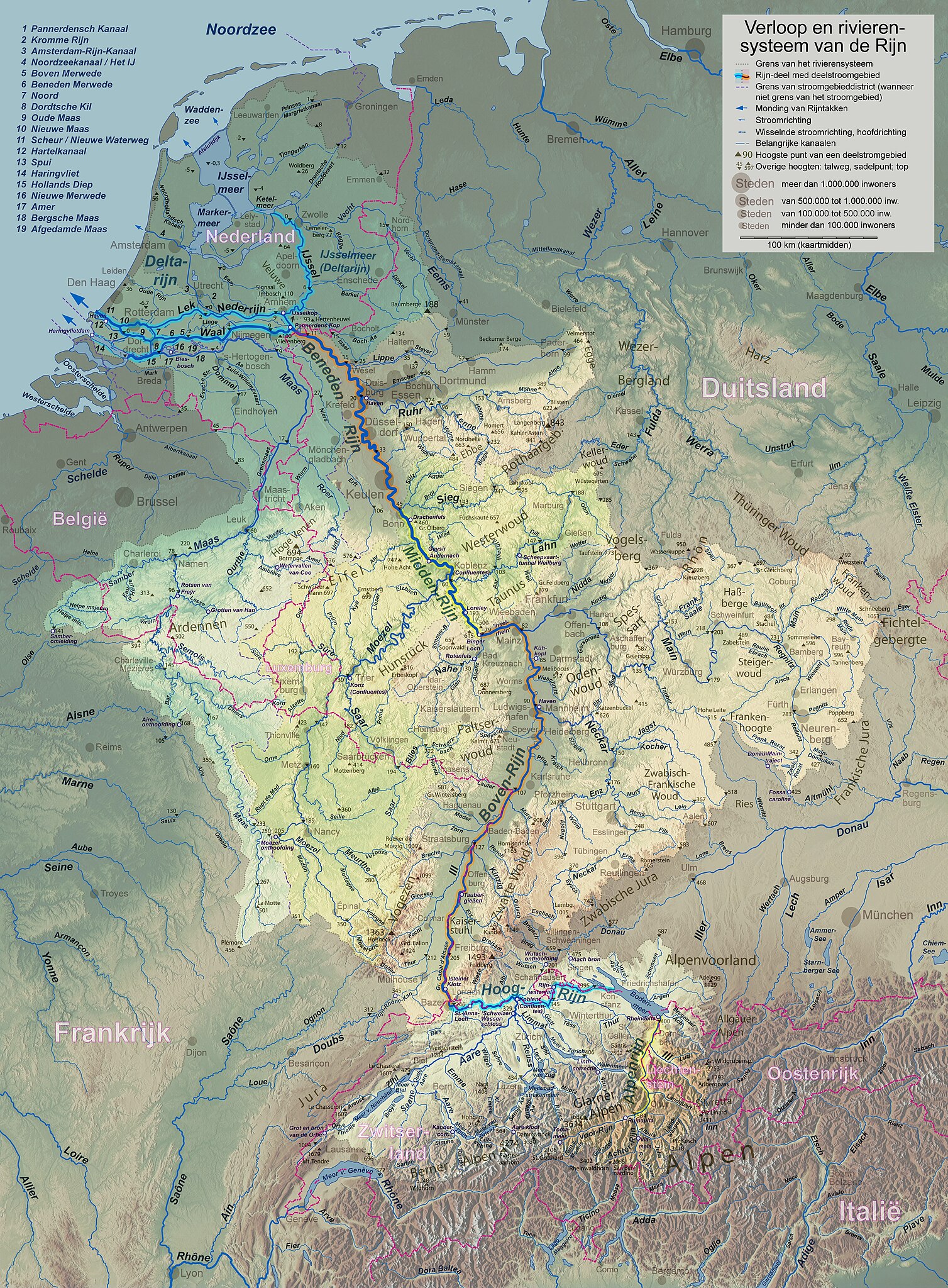
English: Rhine course and river system, place names in dutch Deutsch: Rheinlauf und Flusssystem, niederländisch beschriftet Français : Cours du Rhin et son bassin versant, noms de lieux en néerlandais Nederlands: Verloop en rivierensysteem van de Rijn, plaatsnamen in Nederlands |
| Datum | |
| Boarne | Eigen wurk |
| Auteur | WWasser |
| Oare ferzjes | Versions in german, english, french, or with local names. For other languages the unlabelled version may be used. There are also less detailed maps of the river system with either german, english, french, dutch, or local names. A small version without names is available, too. |
| Camera location | | View this and other nearby images on: OpenStreetMap |
|---|
- Background relief created with Google Maps-For-Free SRTM3 Webserver
- Topography derived from Open Street Map
- Outlines of catchment areas derived from relief data (in the Netherlands also taken from several ICPR (International Commission for the Protection of the Rhine)- and Rijkswaterstaat-publications)
Lisinsje
I, the copyright holder of this work, hereby publish it under the following license:
This file is licensed under the Creative Commons Attribution-Share Alike 3.0 Unported license.
- Fiel jo frij:
- te dielen – it wurk te kopiearjen, fersprieden en út te stjoeren
- te fermingen – it wurk oan te passen
- Under de neikommende betingsten:
- Nammefermelding – You must give appropriate credit, provide a link to the license, and indicate if changes were made. You may do so in any reasonable manner, but not in any way that suggests the licensor endorses you or your use.
- Lyk diele – If you remix, transform, or build upon the material, you must distribute your contributions under the same or compatible license as the original.
Triemskiednis
Klik op in datum/tiid om it bestân te besjen sa't it op dat stuit wie.
| Datum/Tiid | Miniatuer | ôfmjittings | Meidogger | Opmerking | |
|---|---|---|---|---|---|
| lêste | 17 sep 2017, 20.29 | | 3.198 × 4.343 (11,74 MB) | WWasser | Albertkanaal, Aa (Dommel), frontier lines in Lake of Constance |
| 18 apr 2013, 15.37 |  | 2.399 × 3.255 (4,71 MB) | WWasser | some more details | |
| 4 apr 2013, 18.47 |  | 2.131 × 2.893 (4,23 MB) | WWasser | {{Information |Description ={{en|1=legend and colours improved, more toponyms translated}} |Source =own work |Author =Wolfgang Wasser |Date = |Permission = |other_versions = }} | |
| 5 mrt 2013, 16.21 |  | 2.131 × 2.894 (3,32 MB) | WWasser | some smaller rivers, elevations | |
| 8 feb 2013, 14.51 |  | 2.131 × 2.894 (2,98 MB) | WWasser | {{Information |Description ={{en|1=colours improved}} |Source =own |Author =WWasser |Date = |Permission = |other_versions = }} | |
| 7 feb 2013, 16.28 |  | 2.131 × 2.894 (3 MB) | WWasser | resolution reduced | |
| 5 feb 2013, 18.05 |  | 4.263 × 5.791 (4,22 MB) | WWasser | User created page with UploadWizard |
Bestânsgebrûk
De neikommende side brûkt dit bestân:
Globaal bestânsgebrûk
De neikommende oare wiki's brûke dit bestân: