Ofbyld:German losses after WWI.svg

Size of this PNG preview of this SVG file: 707 × 600 piksels. Oare resolúsjes: 283 × 240 piksels | 566 × 480 piksels | 906 × 768 piksels | 1.208 × 1.024 piksels | 2.415 × 2.048 piksels | 1.000 × 848 piksels.
Oarspronklik bestân (SVG-bestân, nominaal 1.000 × 848 pixels, bestânsgrutte: 579 KB)
| Beskriuwing |
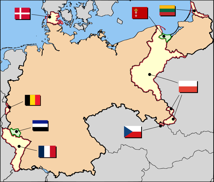
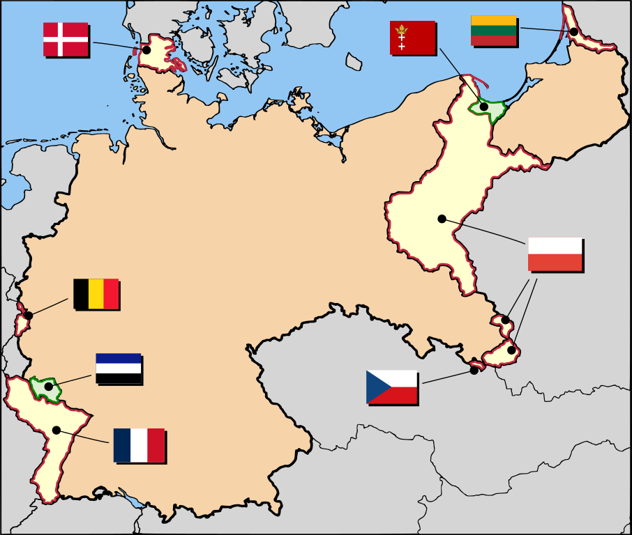
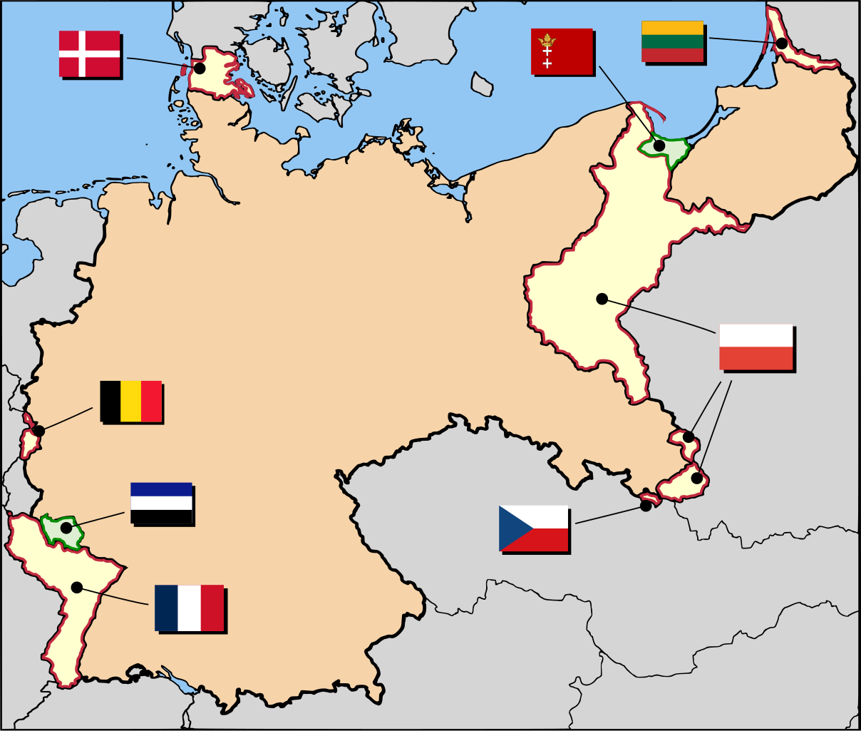
English: Final German territorial losses after World War I.
Українська: Остаточні втрати територій Німеччиною після Першої світової війни.
العربية: المناطق الألمانية المقتطعة بعد الحرب العالمية الأولى |
| Datum | |
| Boarne | Based on Afbeelding:Duitsland1914-1923.png from the Dutch Wikipedia |
| Auteur | User:52 Pickup |
| Tastimming (Reusing this file) |
This file is licensed under the Creative Commons Attribution-Share Alike 2.5 Generic license.
|
Triemskiednis
Klik op in datum/tiid om it bestân te besjen sa't it op dat stuit wie.
| Datum/Tiid | Miniatuer | ôfmjittings | Meidogger | Opmerking | |
|---|---|---|---|---|---|
| lêste | 30 okt 2019, 17.42 | | 1.000 × 848 (579 KB) | Havsjö | flags updated |
| 9 des 2007, 19.33 |  | 1.000 × 848 (562 KB) | 52 Pickup | {{Information| |Description= Ultimate German territorial losses after WWI |Source= Based on nl:Afbeelding:Duitsland1914-1923.png from the Dutch Wikipedia |Author= User:52 Pickup |Permission={{Cc-by-sa-2.5}} |other_versions= }} |
Bestânsgebrûk
De neikommende side brûkt dit bestân:
Globaal bestânsgebrûk
De neikommende oare wiki's brûke dit bestân:
- Gebrûk op af.wikipedia.org
- Gebrûk op an.wikipedia.org
- Gebrûk op ar.wikipedia.org
- Gebrûk op ast.wikipedia.org
- Gebrûk op az.wikipedia.org
- Gebrûk op ba.wikipedia.org
- Gebrûk op be.wikipedia.org
- Gebrûk op bg.wikipedia.org
- Gebrûk op br.wikipedia.org
- Gebrûk op ca.wikipedia.org
- Gebrûk op csb.wikipedia.org
- Gebrûk op cs.wikipedia.org
- Gebrûk op da.wikipedia.org
- Gebrûk op en.wikipedia.org
- Treaty of Versailles
- Weimar Republic
- Former eastern territories of Germany
- Causes of World War II
- German nationalism
- Klaipėda Revolt
- French war planning 1920–1940
- Territorial evolution of Germany
- User talk:Stor stark7/Archive 1
- User:Antidiskriminator/Drafts of articles/Nationalization of history
- Nationalization of history
- User:Falcaorib
- Gebrûk op en.wikibooks.org
- Gebrûk op eo.wikipedia.org
Mear globaal gebrûk fan dit bestân besjen.