Ofbyld:Location map Washington, D.C. central.png
Gjin hegere resolúsje beskikber.
Location_map_Washington,_D.C._central.png (627 × 599 pixels, bestânsgrutte: 218 KB, MIME-type: image/png)

|
This city map image could be re-created using vector graphics as an SVG file. This has several advantages; see Commons:Media for cleanup for more information. If an SVG form of this image is available, please upload it and afterwards replace this template with
{{vector version available|new image name}}.
It is recommended to name the SVG file “Location map Washington, D.C. central.svg”—then the template Vector version available (or Vva) does not need the new image name parameter. |
| Description |
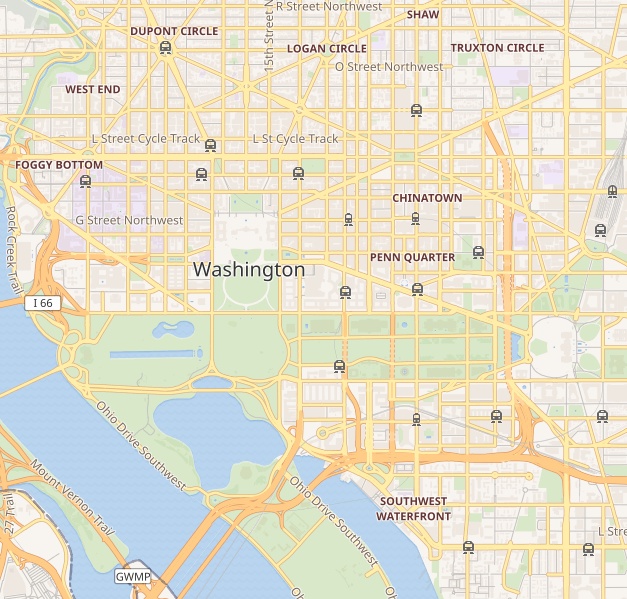
Deze kaart van Washington D.C. is gemaakt op basis van OpenStreetMap projectgegevens, verzameld door de gemeenschap. Deze kaart kan onvolledig zijn en fouten bevatten. Vertrouw er niet op voor navigatie. |
|||||||||
| Datum | (geschiedenis bestand) | |||||||||
| Boarne | openstreetmap.org | |||||||||
| Makker |
OpenStreetMap bijdragers |
|||||||||
| Tastimming (Reusing this file) |
OpenStreetMap-gegevens en -kaarten zijn gelicentieerd onder de Creative Commons Attribution-ShareAlike 2.0-licentie (CC-BY-SA 2.0). This file is licensed under the Creative Commons Attribution-Share Alike 2.0 Generic license.
|
|||||||||
| Geotemporal data | ||||||||||
| Bounding box |
|
|||||||||
| Georeferencing | If inappropriate please set warp_status = skip to hide. | |||||||||
Triemskiednis
Klik op in datum/tiid om it bestân te besjen sa't it op dat stuit wie.
| Datum/Tiid | Miniatuer | ôfmjittings | Meidogger | Opmerking | |
|---|---|---|---|---|---|
| lêste | 8 sep 2018, 22.41 | | 627 × 599 (218 KB) | LinkTiger | Get same image from Wikimedia's map server: https://maps.wikimedia.org/img/osm-intl,14,38.893,-77.03075,627x599.png It's still bad, but maybe not quite as bad? |
| 21 apr 2016, 15.23 |  | 796 × 761 (713 KB) | LinkTiger | Use latest OpenStreetMap style, which includes GSoC road visibility updates | |
| 6 nov 2013, 10.33 |  | 796 × 761 (662 KB) | Ebywan | Update to current OpenStreetMap data | |
| 26 mai 2010, 20.34 |  | 796 × 761 (579 KB) | Dr. Blofeld~commonswiki | {{Information |Description={{en|1=j}} |Source=j |Author=j |Date=j |Permission= |other_versions= }} |
Bestânsgebrûk
De neikommende 3 siden brûke dit bestân:
Globaal bestânsgebrûk
De neikommende oare wiki's brûke dit bestân:
- Gebrûk op ar.wikipedia.org
- Gebrûk op bh.wikipedia.org
- Gebrûk op bn.wikipedia.org
- Gebrûk op ceb.wikipedia.org
- Gebrûk op ce.wikipedia.org
- Gebrûk op en.wikipedia.org
- United States Capitol
- Vietnam Veterans Memorial
- White House
- National Academies of Sciences, Engineering, and Medicine
- Lincoln Memorial
- Washington Monument
- National Air and Space Museum
- Hart Senate Office Building
- Jefferson Memorial
- John F. Kennedy Center for the Performing Arts
- Franklin Delano Roosevelt Memorial
- Ford's Theatre
- Korean War Veterans Memorial
- World War II Memorial
- United States Holocaust Memorial Museum
- Watergate complex
- Ronald Reagan Building and International Trade Center
- George Mason Memorial
- Russell Senate Office Building
- Cannon House Office Building
- Corcoran Gallery of Art
- Arts and Industries Building
- Willard InterContinental Washington
- International Spy Museum
- Mayflower Hotel
- National Postal Museum
- National Museum of Women in the Arts
- J. Edgar Hoover Building
- Cathedral of St. Matthew the Apostle (Washington, D.C.)
- President's Park
- Dirksen Senate Office Building
- District of Columbia War Memorial
- Washington Circle
- S. Dillon Ripley Center
- Eisenhower Executive Office Building
- National Museum of African Art
- St. John's Episcopal Church, Lafayette Square
- United States Supreme Court Building
Mear globaal gebrûk fan dit bestân besjen.