Ofbyld:Map-Germany-1947.svg

Size of this PNG preview of this SVG file: 706 × 599 piksels. Oare resolúsjes: 283 × 240 piksels | 566 × 480 piksels | 905 × 768 piksels | 1.206 × 1.024 piksels | 2.413 × 2.048 piksels | 3.482 × 2.956 piksels.
Oarspronklik bestân (SVG-bestân, nominaal 3.482 × 2.956 pixels, bestânsgrutte: 559 KB)
Gearfetting
| Beskriuwing |
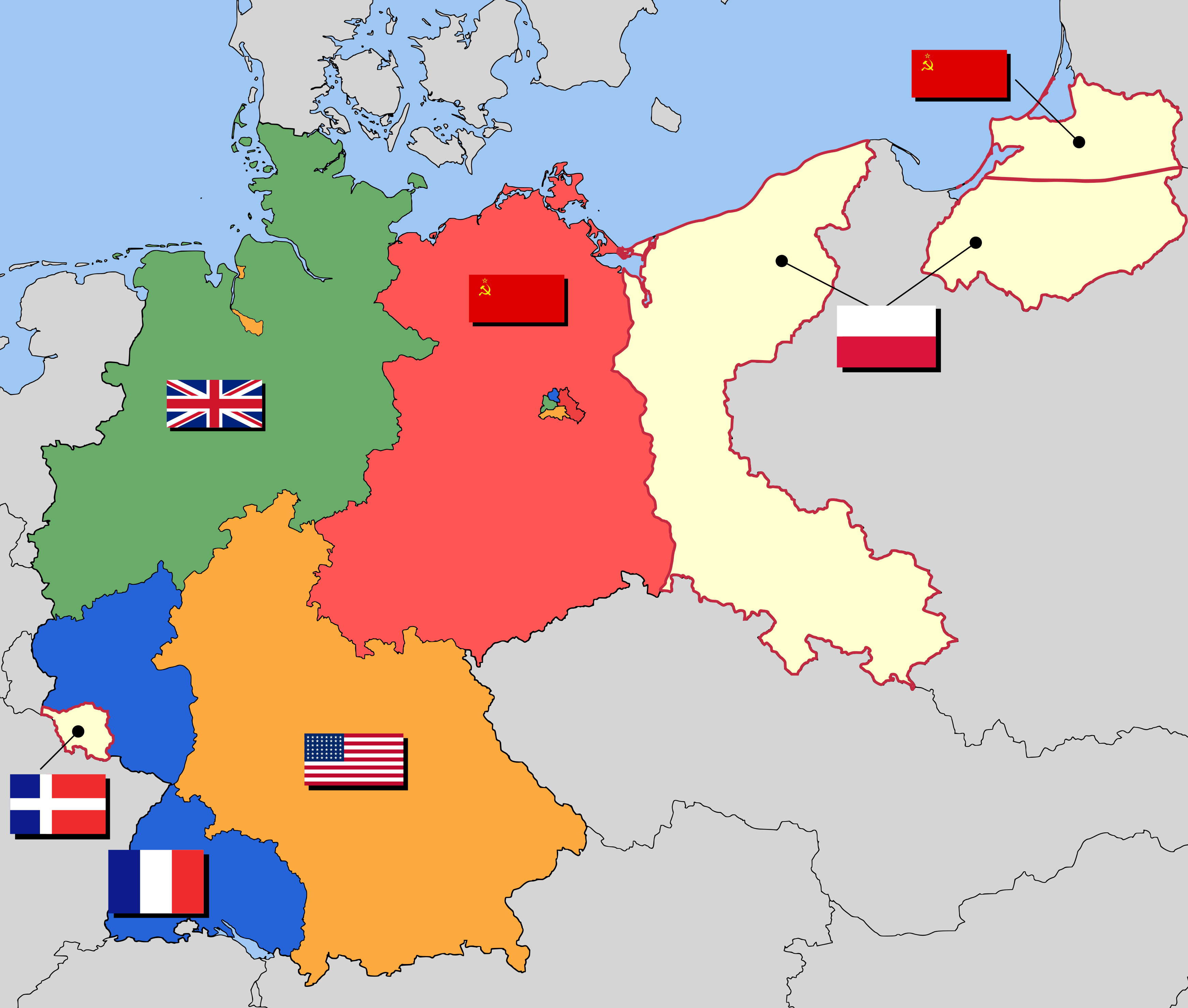
English: Occupation zone borders in Germany, 1947. The territories east of the Oder-Neisse line, under Polish and Soviet administration/annexation, are shown as white as is the likewise detached Saar protectorate. Berlin is the multinational area within the Soviet zone.
Deutsch: Grenzen der Besatzungszonen in Deutschland um 1947. Die Gebiete östlich von der Oder-Neiße-Grenze sind unter polnischer bzw. sowjetischer Verwaltung und sind weiß dargestellt, wie das Saar Protektorat. Berlin ist das multinationale Gebiet in der sowjetischen Zone.
Čeština: Okupační zóny v Německu v roce 1947. Území na východ od linie Odra-Nisa anektované Polskem je zobrazené bílou barvou podobně jako protektorát Sársko. Berlín je několikanárodní oblast uvnitř sovětské zóny.
Bosanski: Granice okupacionih zona u Njemačkoj, 1947 godina. Teritorije istočno od linije Odra-Nisa, ispod Poljske i Sovjetske administracije/okupacije, pokazane su u bijeloj boji, kao i Sarski protektorat. Berlin je multinacionalna regija unutar Sovjetske zone. |
| Datum | |
| Boarne | Own work based on: map data of the IEG-Maps project (Andreas Kunz, B. Johnen and Joachim Robert Moeschl: University of Mainz) - www.ieg-maps.uni-mainz.de. |
| Auteur | 52 Pickup |
| Tastimming (Reusing this file) |
This file is licensed under the Creative Commons Attribution-Share Alike 2.5 Generic license.
|
| Oare ferzjes | Derivative works of this file: EAC Zonenprotokoll 1.png |
| SVG genesis |
Triemskiednis
Klik op in datum/tiid om it bestân te besjen sa't it op dat stuit wie.
| Datum/Tiid | Miniatuer | ôfmjittings | Meidogger | Opmerking | |
|---|---|---|---|---|---|
| lêste | 23 jul 2013, 21.40 | | 3.482 × 2.956 (559 KB) | Ras67 | cropped |
| 15 sep 2008, 02.07 |  | 3.492 × 2.966 (736 KB) | Stor stark7~commonswiki | {{Information| |Description= Occupation zone borders in Germany, 1947. The territories east of the Oder-Neisse line, under Polish and Soviet administration/annexation, are shown as white as is the likewise detached [[Saar (protectorate)|Saar protector |
Bestânsgebrûk
De neikommende side brûkt dit bestân:
Globaal bestânsgebrûk
De neikommende oare wiki's brûke dit bestân:
- Gebrûk op af.wikipedia.org
- Gebrûk op ar.wikipedia.org
- Gebrûk op ast.wikipedia.org
- Gebrûk op be.wikipedia.org
- Gebrûk op bn.wikipedia.org
- Gebrûk op cs.wikipedia.org
- Gebrûk op de.wikipedia.org
- Geschichte Deutschlands
- Zweiter Weltkrieg
- Besatzungszone
- Flagge Deutschlands
- Deutsche Frage
- Deutschland 1945 bis 1949
- Innerdeutsche Beziehungen
- Deutschland
- Wikipedia:Diskussionen über Bilder/Archiv/2008/Dez
- Portal Diskussion:Bremen/Archiv/2008
- Diskussion:Viermächte-Status/Archiv/1
- A Report on Germany
- Gebrûk op de.wikibooks.org
- Gebrûk op el.wikipedia.org
- Gebrûk op en.wikipedia.org
- Gebrûk op es.wikipedia.org
- Gebrûk op fa.wikipedia.org
- Gebrûk op frr.wikipedia.org
- Gebrûk op he.wikipedia.org
- Gebrûk op hu.wikipedia.org
- Gebrûk op id.wikipedia.org
- Gebrûk op is.wikipedia.org
- Gebrûk op ja.wikipedia.org
- Gebrûk op ka.wikipedia.org
Mear globaal gebrûk fan dit bestân besjen.