Ofbyld:Mexico 1824 (equirectangular projection).png

Grutte fan dit proefbyld: 800 × 598 piksels. Oare resolúsjes: 320 × 239 piksels | 640 × 479 piksels | 1.024 × 766 piksels | 1.280 × 957 piksels | 1.400 × 1.047 piksels.
Oarspronklik bestân (1.400 × 1.047 pixels, bestânsgrutte: 405 KB, MIME-type: image/png)

|
This historical map image could be re-created using vector graphics as an SVG file. This has several advantages; see Commons:Media for cleanup for more information. If an SVG form of this image is available, please upload it and afterwards replace this template with
{{vector version available|new image name}}.
It is recommended to name the SVG file “Mexico 1824 (equirectangular projection).svg”—then the template Vector version available (or Vva) does not need the new image name parameter. |
Gearfetting
| Beskriuwing |
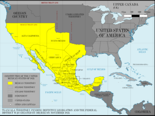
English: First Federal Republic of Mexico in 1824
Español: Primera República Federal de México en 1824. |
| Datum | |
| Boarne |
This image was created with Adobe Photoshop.
|
| Auteur | Giggette |
| Oare ferzjes |
|

.png)
.png)
.png)
| Camera location | | View this and other nearby images on: OpenStreetMap |
|---|
.png¶ms=019.409500_N_-099.130700_E_globe:Earth_type:camera_type:satellite_region:MX_heading:0.00&language=fy)
Lisinsje
I, the copyright holder of this work, hereby publish it under the following licenses:
This file is licensed under the Creative Commons Attribution-Share Alike 3.0 Unported license.
- Fiel jo frij:
- te dielen – it wurk te kopiearjen, fersprieden en út te stjoeren
- te fermingen – it wurk oan te passen
- Under de neikommende betingsten:
- Nammefermelding – You must give appropriate credit, provide a link to the license, and indicate if changes were made. You may do so in any reasonable manner, but not in any way that suggests the licensor endorses you or your use.
- Lyk diele – If you remix, transform, or build upon the material, you must distribute your contributions under the same or compatible license as the original.

|
Der wurdt tastimming jûn ta kopiearjen, fersprieden en/of wizigjen fan dit dokumint ûnder de betinksten fan de GNU-lisinsje foar iepen dokumintaasje, ferzje 1.2, as eltse lettere ferzje útjûn troch de Free Software Foundation; sûnder Ynfariante Seksjes, sûnder Omkaftteksten foar de Foarkante en sûnder Omkaftteksten foar de Efterkante. In kopy fan de lisinsje is opnaam yn de seksje "Text of the GNU Free Documentation License". |
You may select the license of your choice.
Triemskiednis
Klik op in datum/tiid om it bestân te besjen sa't it op dat stuit wie.
| Datum/Tiid | Miniatuer | ôfmjittings | Meidogger | Opmerking | |
|---|---|---|---|---|---|
| lêste | 29 jun 2015, 09.55 | | 1.400 × 1.047 (405 KB) | Illegitimate Barrister | Correction, it was the U.K. at the time, not England. |
| 25 mai 2013, 22.31 |  | 1.400 × 1.047 (420 KB) | Giggette | Design | |
| 25 mai 2013, 04.44 |  | 1.201 × 893 (360 KB) | Giggette | Changes | |
| 18 mai 2013, 10.20 |  | 1.201 × 893 (350 KB) | Giggette | Updating | |
| 17 mai 2013, 22.09 |  | 1.201 × 893 (341 KB) | Giggette | {{Information |Description ={{en|1=Mexico 1824 (equirectangular projection)}} |Source ={{own}} |Author =Giggette |Date =2013-05-17 |Permission = |other_versions = }} |
Bestânsgebrûk
De neikommende 2 siden brûke dit bestân:
Globaal bestânsgebrûk
De neikommende oare wiki's brûke dit bestân:
- Gebrûk op arz.wikipedia.org
- Gebrûk op ast.wikipedia.org
- Gebrûk op azb.wikipedia.org
- Gebrûk op be.wikipedia.org
- Gebrûk op de.wikipedia.org
- Gebrûk op en.wikipedia.org
- Gebrûk op es.wikipedia.org
- Gebrûk op fa.wikipedia.org
- Gebrûk op frr.wikipedia.org
- Gebrûk op hu.wikipedia.org
- Gebrûk op it.wikipedia.org
- Gebrûk op ja.wikipedia.org
- Gebrûk op ko.wikipedia.org
- Gebrûk op pt.wikipedia.org
- Gebrûk op sd.wikipedia.org
- Gebrûk op sq.wikipedia.org
- Gebrûk op sr.wikipedia.org
- Gebrûk op tr.wikipedia.org
.png)