Ofbyld:Mt Eniwa Downhill Course for Sapporo Olympic.jpg

Grutte fan dit proefbyld: 800 × 551 piksels. Oare resolúsjes: 320 × 221 piksels | 640 × 441 piksels | 859 × 592 piksels.
Oarspronklik bestân (859 × 592 pixels, bestânsgrutte: 579 KB, MIME-type: image/jpeg)
Gearfetting
en
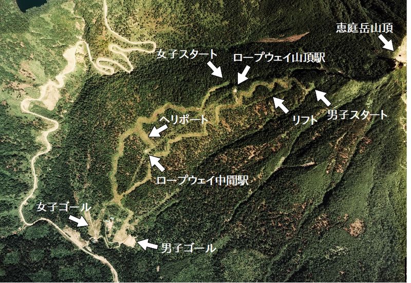
- Description: Drew the Mt. Eniwa downhill course for Sapporo Olympic over the aerial photograph, Chitose, Hokkaido, Japan.
- Source: Image from Country Picture Information (Color Aerial Photo) archive copy at the Wayback Machine resized and drew by Aprilfood
- Date: 1976
ja
- 説明: 札幌オリンピック滑降コースの説明を恵庭岳西部のカラー空中写真上に描いた
- 空中写真の北方向:

- 整理番号: CHO-76-10
- 撮影年度: 昭和51年度 (1976年度)
- 地区名: 樽前山
- 撮影縮尺: 1/15000
- 地形図番号:NK-54-14-12
- 撮影コース: C3B
- 写真番号: 10
- 空中写真の北方向:
- 出典: 国土画像情報(カラー空中写真) archive copy at the Wayback Machineの写真を元にAprilfoodが編集・作成
Lisinsje

|
The copyright holder of this file, the Ministry of Land, Infrastructure, Transport and Tourism of Japan, allows anyone to use it for any purpose, provided that the copyright holder is properly attributed. Redistribution, derivative work, commercial use, and all other use is permitted. |
Nammefermelding:
Copyright © National Land Image Information (Color Aerial Photographs), Ministry of Land, Infrastructure, Transport and Tourism
|
 |
This image is copyrighted by the Ministry of Land, Infrastructure, Transport and Tourism of Japan. For terms of use, see the stipulation to use of National Land Information (in Japanese) and message from MLIT (in Japanese and English). When you display this image on an article, include the following phrase in the description: "Made based on National Land Image Information (Color Aerial Photographs), Ministry of Land, Infrastructure, Transport and Tourism".
|
Triemskiednis
Klik op in datum/tiid om it bestân te besjen sa't it op dat stuit wie.
| Datum/Tiid | Miniatuer | ôfmjittings | Meidogger | Opmerking | |
|---|---|---|---|---|---|
| lêste | 30 sep 2012, 13.59 | | 859 × 592 (579 KB) | Aprilfood | == en == * Description: Drew the Mt. Eniwa downhill course for Sapporo Olympic over the aerial photograph, Chitose, Hokkaido, Japan. * Source: Image from [http://w3land.mlit.go.jp/WebGIS/ Country Picture Information (Color Aerial Photo)] resized and dr... |
Bestânsgebrûk
De neikommende side brûkt dit bestân:
Globaal bestânsgebrûk
De neikommende oare wiki's brûke dit bestân:
- Gebrûk op de.wikipedia.org
- Gebrûk op fr.wikipedia.org
- Gebrûk op it.wikipedia.org
- Gebrûk op ja.wikipedia.org