Ofbyld:PanoBunker.jpg
Grutte fan dit proefbyld: 800 × 396 piksels. Oare resolúsjes: 320 × 158 piksels | 640 × 317 piksels | 1.024 × 507 piksels | 1.280 × 634 piksels | 2.500 × 1.238 piksels.
Oarspronklik bestân (2.500 × 1.238 pixels, bestânsgrutte: 1,26 MB, MIME-type: image/jpeg)
Gearfetting
| Beskriuwing |
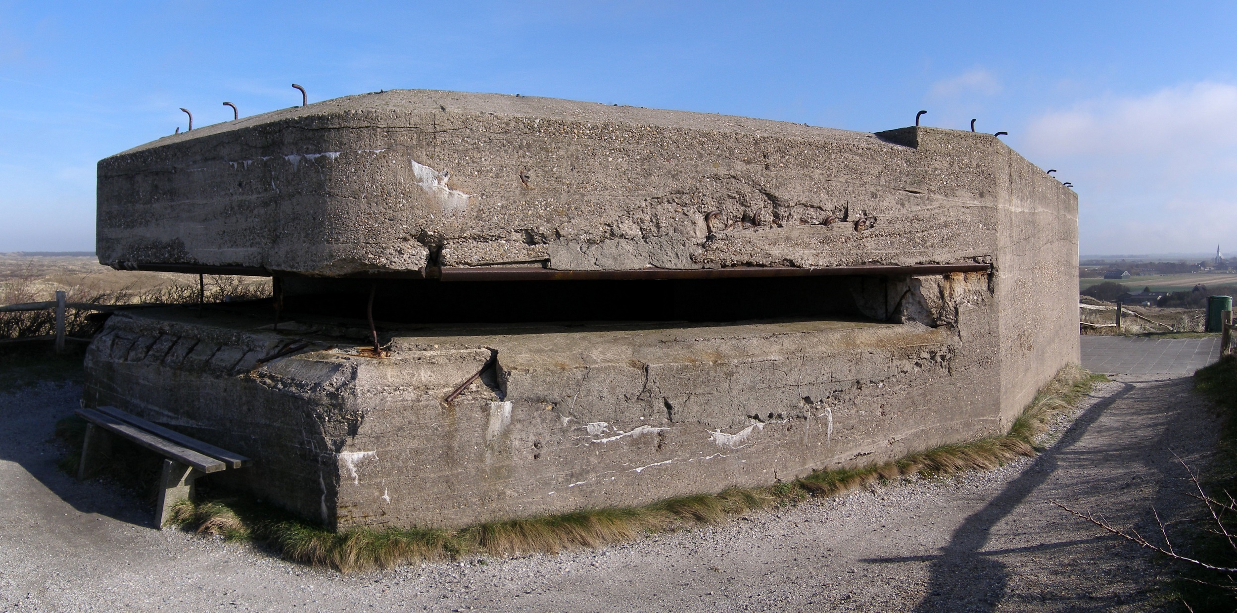
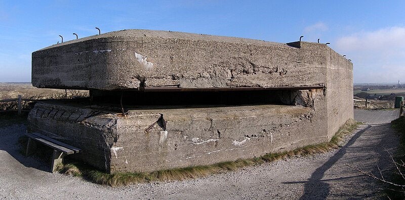
English: Dutch bunker at Loodsmansduin, near Den Hoorn, on the island Texel. The bunker was built in 1938-1939 and was part of the Den Hoorn battery, which defended the naval base Den Helder before World War II. It was later used by the German occupational forces and is now a provincial monument. In the background on the right, the white church of Den Hoorn is just visible.
Panorama of two pictures, stitched with Autostitch.
Türkçe: Hollanda'da bulunan, 1938-1939 senelerinde inşa edilmiş ve II. Dünya Savaşı sırasında Alman işgâl kuvvetleri tarafından kullanılmış bir sığınak. |
| Datum | |
| Boarne | Eigen wurk |
| Auteur | User:China_Crisis |
| Tastimming (Reusing this file) |
[1] |
| Camera location | | View this and other nearby images on: OpenStreetMap |
|---|
This panoramic image was created with Autostitch (stitched images may differ from reality).
Lisinsje
I, China Crisis, the copyright holder of this work, hereby publishes it under the following license:
This file is licensed under the Creative Commons Attribution-Share Alike 2.5 Generic license.
Nammefermelding: I, China Crisis
- Fiel jo frij:
- te dielen – it wurk te kopiearjen, fersprieden en út te stjoeren
- te fermingen – it wurk oan te passen
- Under de neikommende betingsten:
- Nammefermelding – You must give appropriate credit, provide a link to the license, and indicate if changes were made. You may do so in any reasonable manner, but not in any way that suggests the licensor endorses you or your use.
- Lyk diele – If you remix, transform, or build upon the material, you must distribute your contributions under the same or compatible license as the original.
This image has been assessed using the Quality image guidelines and is considered a Quality image.
|
Triemskiednis
Klik op in datum/tiid om it bestân te besjen sa't it op dat stuit wie.
| Datum/Tiid | Miniatuer | ôfmjittings | Meidogger | Opmerking | |
|---|---|---|---|---|---|
| lêste | 8 sep 2007, 18.49 | | 2.500 × 1.238 (1,26 MB) | China Crisis | resized, artefact removed |
| 17 mrt 2007, 13.16 |  | 4.441 × 2.199 (2,19 MB) | China Crisis |
Bestânsgebrûk
De neikommende side brûkt dit bestân:
Globaal bestânsgebrûk
De neikommende oare wiki's brûke dit bestân:
- Gebrûk op az.wikipedia.org
- Gebrûk op bs.wikipedia.org
- Gebrûk op ca.wikipedia.org
- Gebrûk op ca.wiktionary.org
- Gebrûk op de.wikipedia.org
- Gebrûk op el.wikipedia.org
- Gebrûk op en.wikipedia.org
- Gebrûk op es.wikipedia.org
- Gebrûk op fr.wikipedia.org
- Gebrûk op hy.wikipedia.org
- Gebrûk op nl.wikipedia.org
- Gebrûk op pt.wikipedia.org
- Gebrûk op si.wikipedia.org
- Gebrûk op sk.wikipedia.org
- Gebrûk op sv.wikipedia.org
- Gebrûk op tr.wikipedia.org