Ofbyld:Reliefkarte Schweiz3.png

Grutte fan dit proefbyld: 800 × 509 piksels. Oare resolúsjes: 320 × 203 piksels | 640 × 407 piksels | 1.024 × 651 piksels | 1.280 × 814 piksels | 2.560 × 1.628 piksels | 10.226 × 6.503 piksels.
Oarspronklik bestân (10.226 × 6.503 pixels, bestânsgrutte: 61,52 MB, MIME-type: image/png)
| Beskriuwing |
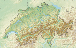
Deutsch: Reliefkarte der Schweiz
Topographischer Hintergrund: NASA Shuttle Radar Topography Mission (public domain). SRTM3 v.2. |
||||||||
| Datum | |||||||||
| Boarne | Eigen wurk | ||||||||
| Auteur | Tschubby | ||||||||
| Tastimming (Reusing this file) |
I, the copyright holder of this work, hereby publish it under the following licenses:
This file is licensed under the Creative Commons Attribution-Share Alike 2.5 Generic, 2.0 Generic and 1.0 Generic license.
You may select the license of your choice. |
||||||||
| Oare ferzjes |
|


|
Triemskiednis
Klik op in datum/tiid om it bestân te besjen sa't it op dat stuit wie.
| Datum/Tiid | Miniatuer | ôfmjittings | Meidogger | Opmerking | |
|---|---|---|---|---|---|
| lêste | 26 des 2021, 15.50 | | 10.226 × 6.503 (61,52 MB) | Tschubby | {{Information |Description= |Source= |Date= |Author= |Permission= |other_versions= }} |
| 13 jun 2014, 12.50 |  | 10.230 × 6.507 (61,48 MB) | Tschubby | {{Information |Description= |Source= |Date= |Author= |Permission= |other_versions= }} | |
| 29 sep 2013, 17.33 |  | 4.256 × 2.708 (21,38 MB) | Tschubby | {{Information |Description= {{de| Reliefkarte der Schweiz}} Topographischer Hintergrund: [http://www2.jpl.nasa.gov/srtm NASA Shuttle Radar Topography Mission] (public domain). SRTM3 v.2. |Source={{own}} |Date= 2013-09-27 |Author= [[:de:User:Tschubby|Ts... |
Bestânsgebrûk
De neikommende 3 siden brûke dit bestân:
Globaal bestânsgebrûk
De neikommende oare wiki's brûke dit bestân:
- Gebrûk op arz.wikipedia.org
- Gebrûk op bg.wikipedia.org
- Берн
- Боденско езеро
- Монтаньола
- Цюрих
- Лозана
- Женева
- Женевско езеро
- Цюрихско езеро
- Монтрьо
- Базел
- Блаузе
- Бриг-Глис
- Каприаска
- Тун
- Колина д'Оро
- Кур (град)
- Мюнхенбухзе
- Муралто
- Фрауенфелд
- Юра (планина)
- Кайзераугст
- Нион
- Вьове
- Дьорфлинген
- Дорнах
- Женолие
- Вилньов
- Давос
- Хомберг (Кантон Берн)
- Люцерн
- Толошна
- Витнау
- Минузио
- Изорно
- Ла Шо дьо Фон
- Хурден
- Трюбах
- Гринделвалд
- Шато дьо Шийон
- Фрибур
- Зенвалд
- Аар
- Морж (град)
- Шаблон:ПК Швейцария
- Баден (Швейцария)
- Аарау
Mear globaal gebrûk fan dit bestân besjen.