Ofbyld:Saxony-Anhalt relief location map.jpg

Grutte fan dit proefbyld: 509 × 600 piksels. Oare resolúsjes: 204 × 240 piksels | 407 × 480 piksels | 652 × 768 piksels | 1.273 × 1.500 piksels.
Oarspronklik bestân (1.273 × 1.500 pixels, bestânsgrutte: 691 KB, MIME-type: image/jpeg)
Gearfetting
| Beskriuwing |
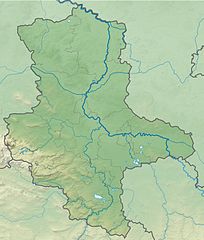
Deutsch: Physische Positionskarte Sachsen-Anhalt, Deutschland. Geographische Begrenzung der Karte:
English: Physical Location map Saxony-Anhalt, Germany. Geographic limits of the map:
|
| Datum | |
| Boarne |
Eigen wurk |
| Auteur | Grundkarte TUBS, Relief Alexrk2 |
| Oare ferzjes |
Derivative works of this file: Regionalgruppen Megalithik Sachsen-Anhalt.png
|


|
This map has been made or improved in the German Kartenwerkstatt (Map Lab). You can propose maps to improve as well.
|
Lisinsje
I, the copyright holder of this work, hereby publish it under the following license:
This file is licensed under the Creative Commons Attribution-Share Alike 3.0 Unported license.
- Fiel jo frij:
- te dielen – it wurk te kopiearjen, fersprieden en út te stjoeren
- te fermingen – it wurk oan te passen
- Under de neikommende betingsten:
- Nammefermelding – You must give appropriate credit, provide a link to the license, and indicate if changes were made. You may do so in any reasonable manner, but not in any way that suggests the licensor endorses you or your use.
- Lyk diele – If you remix, transform, or build upon the material, you must distribute your contributions under the same or compatible license as the original.
Triemskiednis
Klik op in datum/tiid om it bestân te besjen sa't it op dat stuit wie.
| Datum/Tiid | Miniatuer | ôfmjittings | Meidogger | Opmerking | |
|---|---|---|---|---|---|
| lêste | 27 sep 2009, 13.55 | | 1.273 × 1.500 (691 KB) | Alexrk2 | Farbskala angepasst |
| 22 sep 2009, 19.16 |  | 1.273 × 1.500 (716 KB) | Alexrk2 | Darstellungsreihenfolge Flüsse,Seen | |
| 22 sep 2009, 18.07 |  | 1.273 × 1.500 (716 KB) | Alexrk2 | Grenzen korr., Höhenfarbskala angepasst | |
| 17 sep 2009, 18.28 |  | 1.272 × 1.500 (754 KB) | Alexrk2 | == Summary == {{Information |Description= {{de|Physische Positionskarte Sachsen-Anhalt, Deutschland. Geographische Begrenzung der Karte:}} {{en|Physical Location map Saxony-Anhalt, Germany. Geographic limits |
Bestânsgebrûk
De neikommende side brûkt dit bestân:
Globaal bestânsgebrûk
De neikommende oare wiki's brûke dit bestân:
- Gebrûk op ar.wikipedia.org
- Gebrûk op ba.wikipedia.org
- Gebrûk op bg.wikipedia.org
- Магдебург
- Хале (Зале)
- Айзлебен
- Теологичен университет Фриденсау
- Ашерслебен
- Мьокерн
- Магдебургски университет
- Айхенбарлебен
- Цербст
- Мерзебург
- Кведлинбург
- Шьонхаузен
- Шаблон:ПК Германия Саксония-Анхалт
- Ветин
- Витенберг
- Ландсберг (Саксония-Анхалт)
- Наумбург (Заале)
- Тангермюнде
- Арнебург
- Кьотен
- Нинбург (Саксония-Анхалт)
- Баленщет
- Халберщат
- Ермслебен
- Фалкенщайн (Харц)
- Вестдорф
- Пльотцкау
- Цайц
- Бернбург
- Вайсенфелс
- Харцгероде
- Безенщет
- Валхаузен
- Бьорделанд
- Бланкенбург (Саксония-Анхалт)
- Халденслебен
- Вербен (Саксония-Анхалт)
- Алслебен
- Мансфелд
- Акен
- Кверфурт
- Арнщайн
- Алщет
- Илзенбург
- Гозек
- Зангерхаузен
- Десау-Рослау
- Фрайбург (Саксония-Анхалт)
Mear globaal gebrûk fan dit bestân besjen.