Ofbyld:Texas proposed boundaries.svg

Size of this PNG preview of this SVG file: 621 × 600 piksels. Oare resolúsjes: 248 × 240 piksels | 497 × 480 piksels | 795 × 768 piksels | 1.060 × 1.024 piksels | 2.120 × 2.048 piksels | 1.475 × 1.425 piksels.
Oarspronklik bestân (SVG-bestân, nominaal 1.475 × 1.425 pixels, bestânsgrutte: 697 KB)
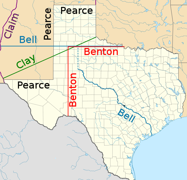
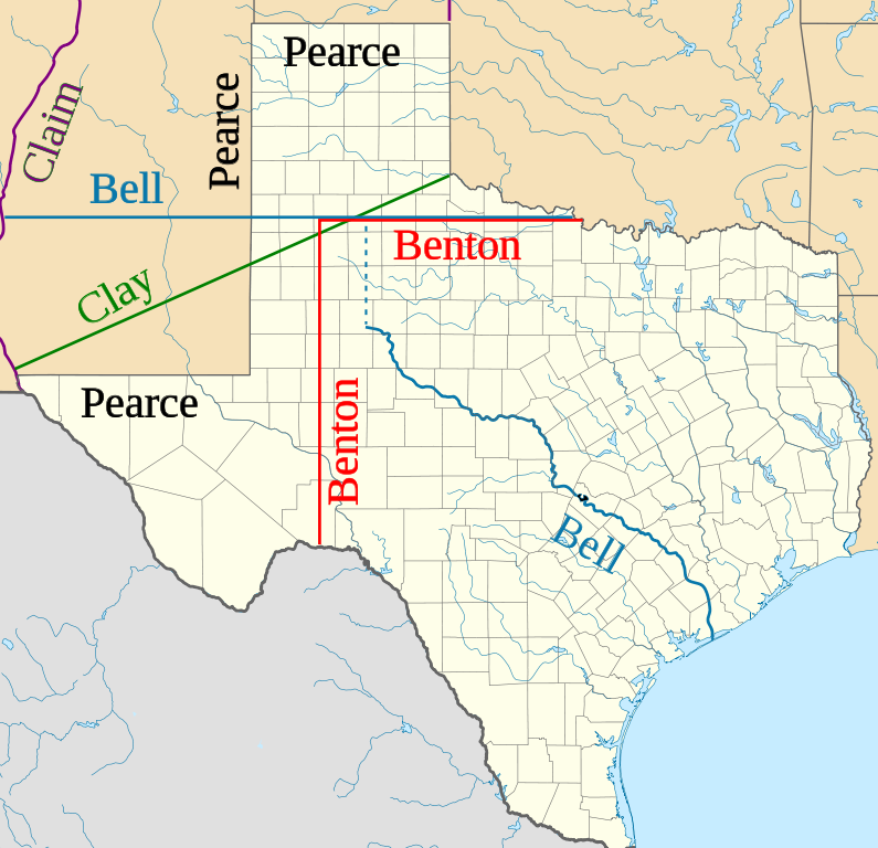
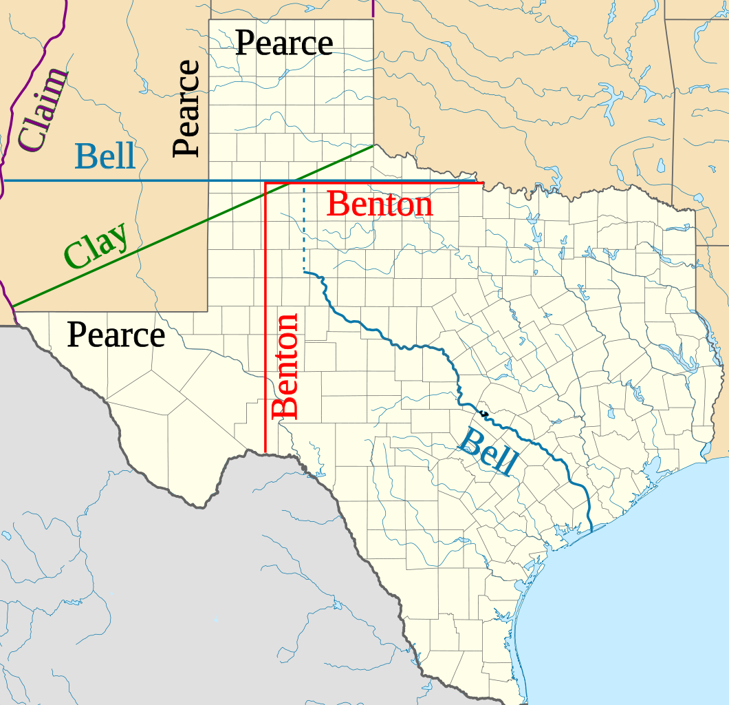
| Beskriuwing | Northern and western boundaries of Texas proposed by various Senators in the Compromise of 1850 debate |
| Datum | (UTC) |
| Boarne | |
| Auteur |
|
| This is a retouched picture, which means that it has been digitally altered from its original version. Modifications: Proposed boundaries for Compromise of 1850. The original can be viewed here: USA Texas location map.svg:
|
I, the copyright holder of this work, hereby publish it under the following licenses:
This file is licensed under the Creative Commons Attribution 3.0 Unported license.
- Fiel jo frij:
- te dielen – it wurk te kopiearjen, fersprieden en út te stjoeren
- te fermingen – it wurk oan te passen
- Under de neikommende betingsten:
- Nammefermelding – You must give appropriate credit, provide a link to the license, and indicate if changes were made. You may do so in any reasonable manner, but not in any way that suggests the licensor endorses you or your use.

|
Der wurdt tastimming jûn ta kopiearjen, fersprieden en/of wizigjen fan dit dokumint ûnder de betinksten fan de GNU-lisinsje foar iepen dokumintaasje, ferzje 1.2, as eltse lettere ferzje útjûn troch de Free Software Foundation; sûnder Ynfariante Seksjes, sûnder Omkaftteksten foar de Foarkante en sûnder Omkaftteksten foar de Efterkante. In kopy fan de lisinsje is opnaam yn de seksje "Text of the GNU Free Documentation License". |
You may select the license of your choice.
Original upload log
This image is a derivative work of the following images:
- File:USA_Texas_location_map.svg licensed with Cc-by-3.0, GFDL
- 2009-06-17T20:30:36Z Alexrk2 1500x1484 (711918 Bytes) enh
- 2009-06-07T13:05:09Z Alexrk 1500x1484 (571429 Bytes) water bodies 1:10mio
- 2009-06-06T21:43:21Z Alexrk 1500x1484 (870861 Bytes) GeneralizationDistance = 2px
- 2009-06-06T17:41:11Z Alexrk 1500x1485 (1550930 Bytes) == Beschreibung == {{Information |Description= {{de|Positionskarte von [[:de:Texas|Texas]], [[:de:USA|USA]]}} Quadratische Plattkarte, N-S-Streckung 120 %. Geographische Begrenzung der Karte: * N: 36.8° N * S: 25.5° N * W:
Uploaded with derivativeFX
Triemskiednis
Klik op in datum/tiid om it bestân te besjen sa't it op dat stuit wie.
| Datum/Tiid | Miniatuer | ôfmjittings | Meidogger | Opmerking | |
|---|---|---|---|---|---|
| lêste | 29 jan 2010, 02.11 | | 1.475 × 1.425 (697 KB) | JWB | Identify more of Pearce and Benton lines |
| 29 jan 2010, 02.03 |  | 1.475 × 1.425 (696 KB) | JWB | Identify final proposal as Pearce's | |
| 29 jan 2010, 01.52 |  | 1.475 × 1.425 (696 KB) | JWB | Tweaks | |
| 29 jan 2010, 01.50 |  | 1.475 × 1.400 (696 KB) | JWB | {{Information |Description=Northern and western boundaries of Texas proposed by various Senators in the Compromise of 1850 debate |Source=*File:USA_Texas_location_map.svg |Date=2010-01-28 23:47 (UTC) |Author=*File:USA_Texas_location_map.svg: [ |
Bestânsgebrûk
De neikommende side brûkt dit bestân:
Globaal bestânsgebrûk
De neikommende oare wiki's brûke dit bestân:
- Gebrûk op af.wikipedia.org
- Gebrûk op azb.wikipedia.org
- Gebrûk op cy.wikipedia.org
- Gebrûk op en.wikipedia.org
- Gebrûk op id.wikipedia.org
- Gebrûk op it.wikipedia.org
- Gebrûk op ja.wikipedia.org
- Gebrûk op kk.wikipedia.org
- Gebrûk op mk.wikipedia.org
- Gebrûk op ms.wikipedia.org
- Gebrûk op pt.wikipedia.org
- Gebrûk op ro.wikipedia.org
- Gebrûk op ru.wikipedia.org
- Gebrûk op th.wikipedia.org
- Gebrûk op uz.wikipedia.org
- Gebrûk op vi.wikipedia.org
- Gebrûk op www.wikidata.org