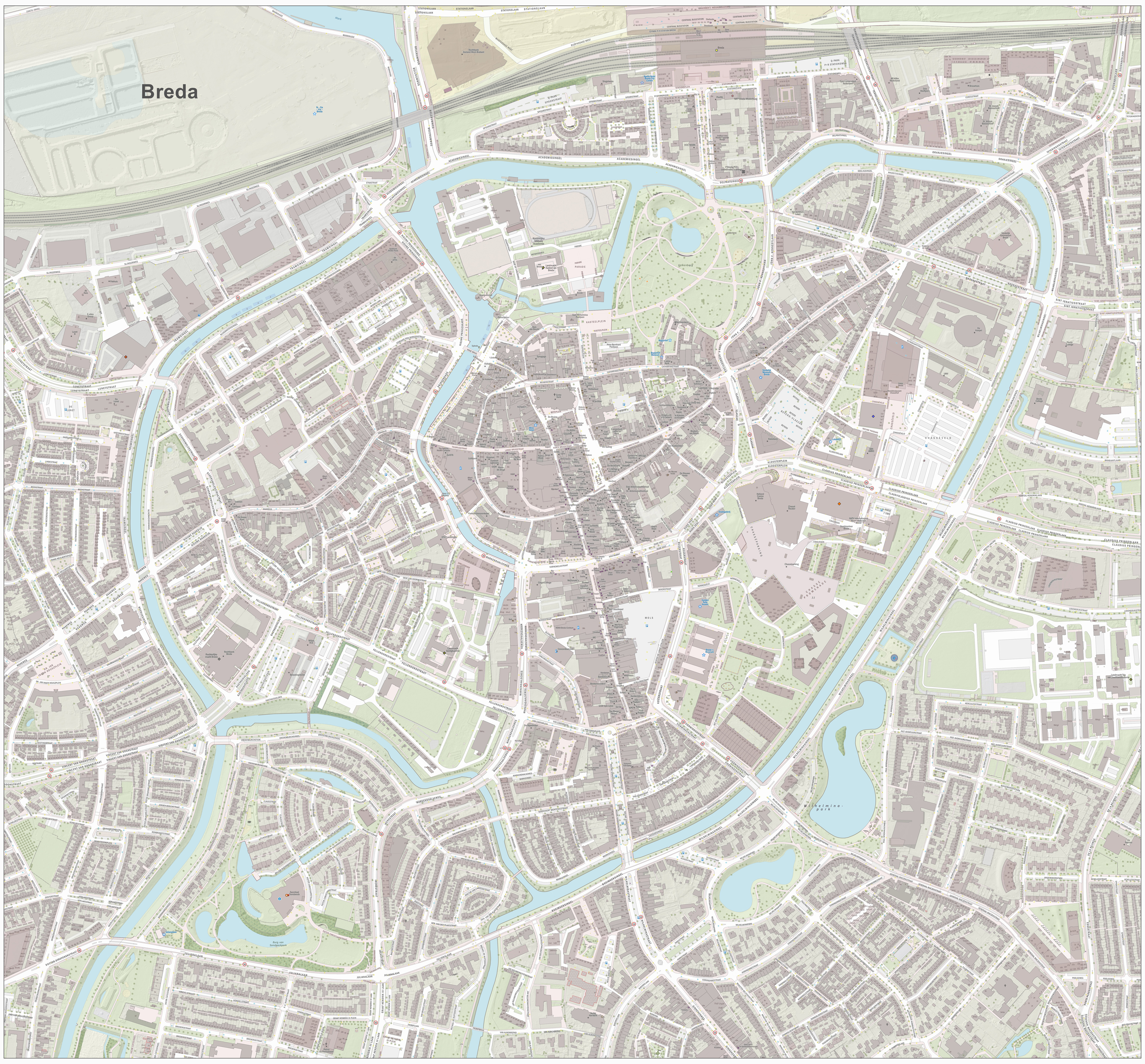
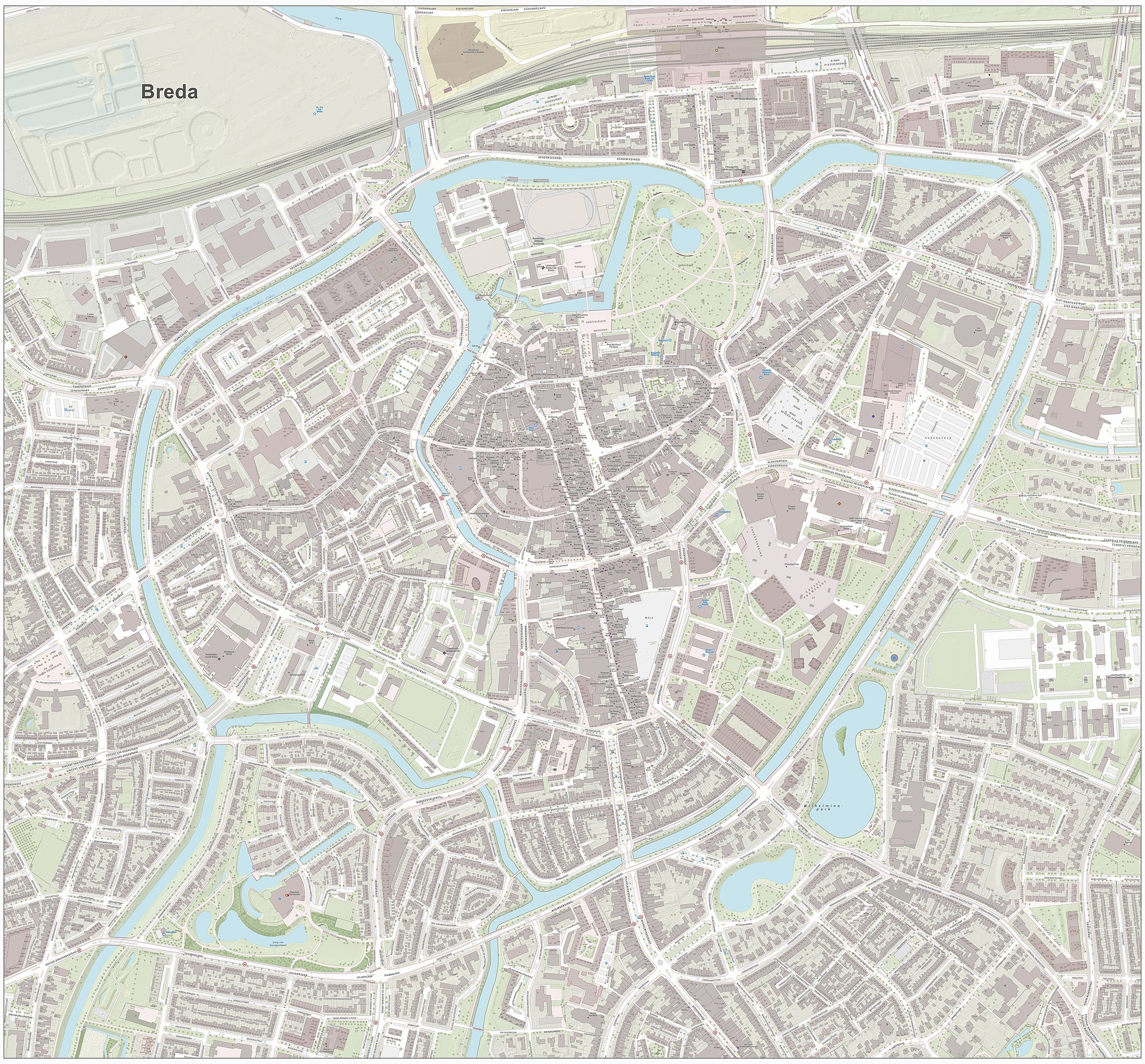
Ofbyld:Breda-centrum-OpenTopo.jpg
Grutte fan dit proefbyld: 645 × 599 piksels. Oare resolúsjes: 258 × 240 piksels | 517 × 480 piksels | 826 × 768 piksels | 1.102 × 1.024 piksels | 2.204 × 2.048 piksels | 6.164 × 5.728 piksels.
Oarspronklik bestân (6.164 × 5.728 pixels, bestânsgrutte: 9,03 MB, MIME-type: image/jpeg)
Gearfetting
| Beskriuwing |
Nederlands: Topografische kaart van Breda (centrum van woonplaats). Resolutie: 2688 pixels/km.
Kaartbeeld samengesteld uit de open geodata van de Basisregistratie Grootschalige Topografie (BGT), Creative Commons-BY Kadaster, en Top10NL en Top25namen (Basisregistratie Topografie, Kadaster), Creative Commons-BY Kadaster. Gebouwvlakken uit open geodata BAG extract, Creative Commons-BY Kadaster. Wegen uit de OpenStreetMap, CC-BY OpenStreetMap bijdragers. Reliëfschaduw uit de Actuele Hoogtekaart AHN2/AHN3. Samenstelling en kleurenschema: Jan-Willem van Aalst, met QGIS2. Zie ook de Legenda. |
| Datum | |
| Boarne | Eigen wurk |
| Auteur | Janwillemvanaalst |
Lisinsje
I, the copyright holder of this work, hereby publish it under the following license:
This file is licensed under the Creative Commons Attribution-Share Alike 4.0 International license.
- Fiel jo frij:
- te dielen – it wurk te kopiearjen, fersprieden en út te stjoeren
- te fermingen – it wurk oan te passen
- Under de neikommende betingsten:
- Nammefermelding – You must give appropriate credit, provide a link to the license, and indicate if changes were made. You may do so in any reasonable manner, but not in any way that suggests the licensor endorses you or your use.
- Lyk diele – If you remix, transform, or build upon the material, you must distribute your contributions under the same or compatible license as the original.
Triemskiednis
Klik op in datum/tiid om it bestân te besjen sa't it op dat stuit wie.
| Datum/Tiid | Miniatuer | ôfmjittings | Meidogger | Opmerking | |
|---|---|---|---|---|---|
| lêste | 1 mai 2017, 20.58 | | 6.164 × 5.728 (9,03 MB) | Janwillemvanaalst | Higher resolution rendering, combining elements of the new Dutch Base Registry of Large-scale Topography (BGT), CC-BY Dutch Kadaster. Also incorporated: elements of the OpenStreetMap (OSM), CC-BY OSM contributors. |
| 14 mai 2016, 18.21 |  | 1.824 × 1.582 (2,15 MB) | Janwillemvanaalst | Error correction on terrain and labels, May 2016 | |
| 7 mai 2016, 16.50 |  | 1.960 × 1.729 (2,5 MB) | Janwillemvanaalst | Map layers update, April 2016 | |
| 20 des 2014, 13.18 |  | 1.588 × 1.336 (1,38 MB) | Janwillemvanaalst | User created page with UploadWizard |
Bestânsgebrûk
De neikommende 6 siden brûke dit bestân:
Globaal bestânsgebrûk
De neikommende oare wiki's brûke dit bestân:
- Gebrûk op de.wikipedia.org
- Gebrûk op fr.wikipedia.org
- Gebrûk op nl.wikipedia.org