Ofbyld:LlanoEstacadoShadedRelief.jpg
Gjin hegere resolúsje beskikber.
LlanoEstacadoShadedRelief.jpg (302 × 365 pixels, bestânsgrutte: 32 KB, MIME-type: image/jpeg)


Gearfetting
| Beskriuwing |
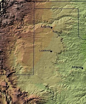
English: Shaded Relief Map of the Llano Estacado clipped from .pdf created by USGS National Map Viewer |
| Boarne |
http://nmviewogc.cr.usgs.gov/viewer.htm
|
| Auteur |
Lisinsje
This image is in the public domain in the United States because it only contains materials that originally came from the United States Geological Survey, an agency of the United States Department of the Interior. For more information, see the official USGS copyright policy.
|
Original upload log
The original description page was here. All following user names refer to en.wikipedia.
Triemskiednis
Klik op in datum/tiid om it bestân te besjen sa't it op dat stuit wie.
| Datum/Tiid | Miniatuer | ôfmjittings | Meidogger | Opmerking | |
|---|---|---|---|---|---|
| lêste | 26 des 2008, 17.04 | | 302 × 365 (32 KB) | File Upload Bot (Magnus Manske) | {{BotMoveToCommons|en.wikipedia}} {{Information |Description={{en|Shaded Relief Map of the Llano Estacado clipped from .pdf created by USGS National Map Viewer http://nmviewogc.cr.usgs.gov/viewer.htm}} |Source=Transferred from [http://en.wikipedia.org en |
Bestânsgebrûk
De neikommende side brûkt dit bestân:
Globaal bestânsgebrûk
De neikommende oare wiki's brûke dit bestân:
- Gebrûk op de.wikipedia.org
- Gebrûk op el.wikipedia.org
- Gebrûk op en.wikipedia.org
- Gebrûk op eo.wikipedia.org
- Gebrûk op es.wikipedia.org
- Gebrûk op eu.wikipedia.org
- Gebrûk op fa.wikipedia.org
- Gebrûk op fr.wikipedia.org
- Gebrûk op ja.wikipedia.org
- Gebrûk op kk.wikipedia.org
- Gebrûk op nl.wikipedia.org
- Gebrûk op no.wikipedia.org
- Gebrûk op pt.wikipedia.org
- Gebrûk op ro.wikipedia.org
- Gebrûk op ru.wikipedia.org
- Gebrûk op uk.wikipedia.org
- Gebrûk op uz.wikipedia.org
- Gebrûk op www.wikidata.org