Ofbyld:Onstwedde gemeenteatlas Kuyper.tif

Size of this JPG preview of this TIF file: 470 × 600 piksels. Oare resolúsjes: 188 × 240 piksels | 376 × 480 piksels | 602 × 768 piksels | 802 × 1.024 piksels | 1.918 × 2.448 piksels.
Oarspronklik bestân (1.918 × 2.448 pixels, bestânsgrutte: 576 KB, MIME-type: image/tiff)
Gearfetting
| Beskriuwing |
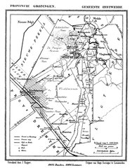
Nederlands: kaart van de voormalige gemeente onstwedde in de gemeenteatlas van Jacob Kuyper uit 1867 |
|||||||||||||||||||||||
| Datum | ||||||||||||||||||||||||
| Boarne | Gemeente-atlas van Nederland - 9e deel - Groningen | |||||||||||||||||||||||
| Auteur |
|
|||||||||||||||||||||||
.png)
Lisinsje
|
This work is in the public domain in its country of origin and other countries and areas where the copyright term is the author's life plus 70 years or fewer. This work is in the public domain in the United States because it was published (or registered with the U.S. Copyright Office) before January 1, 1929. | |
| This file has been identified as being free of known restrictions under copyright law, including all related and neighboring rights. | |
Triemskiednis
Klik op in datum/tiid om it bestân te besjen sa't it op dat stuit wie.
| Datum/Tiid | Miniatuer | ôfmjittings | Meidogger | Opmerking | |
|---|---|---|---|---|---|
| lêste | 6 des 2017, 13.51 |  | 1.918 × 2.448 (576 KB) | Gouwenaar | {{Information |Description={{nl|kaart van de voormalige gemeente onstwedde in de gemeenteatlas van Jacob Kuyper uit 1867}} |Source=Gemeente-atlas van Nederland - 9e deel - Groningen |Date=1867 |Author={{Creator:Jacob Kuyper}} |Permission= |other_versi... |
Bestânsgebrûk
De neikommende 2 siden brûke dit bestân:
Globaal bestânsgebrûk
De neikommende oare wiki's brûke dit bestân:
- Gebrûk op nl.wikipedia.org