Ofbyld:2018-P02-Friesland.jpg

Grutte fan dit proefbyld: 733 × 600 piksels. Oare resolúsjes: 293 × 240 piksels | 587 × 480 piksels | 939 × 768 piksels | 1.252 × 1.024 piksels | 2.503 × 2.048 piksels | 2.914 × 2.384 piksels.
Oarspronklik bestân (2.914 × 2.384 pixels, bestânsgrutte: 1.010 KB, MIME-type: image/jpeg)
Gearfetting
| Beskriuwing |
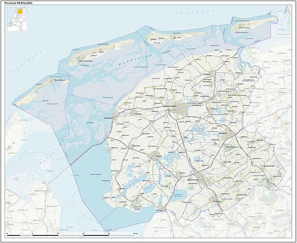
English: Toographic overview map of the Dutch Province of Friesland as of 2018. Compiled by Jan-Willem van Aalst using Dutch Governmental open data (CC-BY Kadaster) and OpenStreetMap data (CC-BY OpenStreetMap contributors).
Nederlands: Topografische overzichtskaart van de Nederlandse provincie Friesland per 2018. Kaartbeeld samengesteld door Jan-Willem van Aalst uit Nederlandse open overheidsdata (CC-BY Kadaster) en OpenStreetMap data (CC-BY OpenStreetMap bijdragers). |
| Datum | |
| Boarne | Eigen wurk |
| Auteur | Janwillemvanaalst |
Lisinsje
I, the copyright holder of this work, hereby publish it under the following license:
This file is licensed under the Creative Commons Attribution-Share Alike 4.0 International license.
- Fiel jo frij:
- te dielen – it wurk te kopiearjen, fersprieden en út te stjoeren
- te fermingen – it wurk oan te passen
- Under de neikommende betingsten:
- Nammefermelding – You must give appropriate credit, provide a link to the license, and indicate if changes were made. You may do so in any reasonable manner, but not in any way that suggests the licensor endorses you or your use.
- Lyk diele – If you remix, transform, or build upon the material, you must distribute your contributions under the same or compatible license as the original.
Triemskiednis
Klik op in datum/tiid om it bestân te besjen sa't it op dat stuit wie.
| Datum/Tiid | Miniatuer | ôfmjittings | Meidogger | Opmerking | |
|---|---|---|---|---|---|
| lêste | 31 des 2017, 15.14 | | 2.914 × 2.384 (1.010 KB) | Janwillemvanaalst | User created page with UploadWizard |
Bestânsgebrûk
Mear as 100 siden brûke dit bestân. De neikommende list jout allinne de earste 100 siden dy't dit bestân brûke wer. Der is ek in folsleine list.
- Abbegea
- Akkrum
- Aldeboarn
- Aldwâld
- Augsbuert-Lytsewâld
- Bantegea
- Bartlehiem
- Beslingastate
- Boerum
- Brantgum
- Britsum
- Broeksterwâld
- Bueren (It Amelân)
- Burdaard
- Burgum
- Damwâld
- De Gordyk
- De Jouwer
- De Lemmer
- De Lytse Jouwer
- De Pomp
- De Westereen
- Dearsum (Súdwest-Fryslân)
- Dokkum
- Driezum
- Droegeham
- Drylts
- Eagum
- Ealsum
- Eanjum
- Eastermar
- Easternijtsjerk
- Eastrum
- Feankleaster
- Feanwâlden
- Ferwert
- Foudgum
- Friens
- Frjentsjer
- Gau
- Ginnum
- Grou (plak)
- Hantum
- Hantumhuzen
- Harstastate
- Heech
- Hegebeintum
- Holwert
- Hurdegaryp
- Hylpen
- Ie (Noardeast-Fryslân)
- Iesumasyl
- Jannum
- Jirnsum
- Jislum
- Jorwert
- Jouswier
- Ketlik
- Kollum
- Kollumersweach
- Langwar
- Lichtaard
- Ljussens
- Mantgum
- Mildaam
- Mitselwier
- Moarre
- Moddergat
- Muntsjesyl
- Nes (It Hearrenfean)
- Nes (Noardeast-Fryslân)
- Nijewier
- Nijskoat
- Noardburgum
- Noardwâlde (Weststellingwerf)
- Oentsjerk
- Peazens (plak)
- Penjum
- Raard
- Raerd
- Reduzum
- Rinsumageast
- Sibrandahûs (Dantumadiel)
- Sigerswâld (Opsterlân)
- Sint-Nyk
- Skearnegoutum
- Sleat (stêd)
- Starum
- Surhústerfean
- Ternaard
- Toppenhuzen
- Twellingea
- Twizelerheide
- Waaksens (Noardeast-Fryslân)
- Warfstermûne
- Warkum
- Wergea
- Wetsens
- Wierum
- Wommels
Mear ferwizings nei dit bestân besjen.
Globaal bestânsgebrûk
De neikommende oare wiki's brûke dit bestân:
- Gebrûk op ar.wikipedia.org
- Gebrûk op ast.wikipedia.org
- Gebrûk op cv.wikipedia.org
- Gebrûk op da.wikipedia.org
- Gebrûk op de.wikipedia.org
- Gebrûk op en.wikipedia.org
- Gebrûk op eo.wikipedia.org
- Gebrûk op es.wikipedia.org
- Gebrûk op fi.wikipedia.org
- Gebrûk op fo.wikipedia.org
- Gebrûk op ku.wikipedia.org
- Gebrûk op nl.wikipedia.org
- Dokkum
- Leeuwarden (stad)
- Griend (zandplaat)
- Harlingen (stad)
- Sloten (Friesland)
- Oudemirdum
- Friese elf steden
- Rauwerd
- Franekeradeel (1984-2018)
- Het Bildt
- Ferwerderadeel
- Dongeradeel
- IJlst (stad)
- Mildam
- Sneek (stad)
- Balk (Friesland)
- Tjonger
- Skarsterlân
- Menaldumadeel
- Leeuwarderadeel
- Kollumerland en Nieuwkruisland
- Bolsward
- Sexbierum
- Wierum (Friesland)
- West-Terschelling
- Brandaris (vuurtoren)
- Poppingawier
- Zurich (Nederland)
- Nieuweschoot
- Vuurduin
- Vuurtoren Ameland
- Franeker
- Stavoren
- Wolvega
- Irnsum
- Drachten
- Donkerbroek
- Bantega
Mear globaal gebrûk fan dit bestân besjen.